Después de mi primer intento de viaje en bicicleta, que terminó antes de lo previsto, empecé a planificar otro viaje. Esta vez entrené un poco más, me mudé a Bariloche a mitad de año así que tenía varios caminos de montaña para entrenar, a diferencia de La Pampa donde es todo bastante más plano.
Así llegó enero de 2011, con más entrenamiento y no tanto tiempo, así que mirando un poco el mapa cerca de Bariloche, se me ocurrió un recorrido por acá cerca nomás: La idea era salir desde la confluencia del río Limay y Traful (donde está la estación de servicio del ACA) hacia Villa Traful, empalmar la ruta de los Siete Lagos (que va desde San Martín de Los Andes a Bariloche), seguir hacia el Norte, y después tomar el desvío a Villa Meliquina para volver a Confluencia por Paso Córdoba.
After
my first bike trip ended a little bit soon, I started planning another
one. This time I trained some more, I was living in Bariloche so I had
some hilly roads to train, compared with La Pampa which is mainly flat.
So january 2011 arrived, I was more trained but didn’t have too much time, so looking the map near Bariloche I found a route not so far away: The idea was to start at the junction between Traful and Limay rivers (where there is a gas station) heading to Trafull Village, connect with the Seven Lakes road (which goes from San Martín de Los Andes to Bariloche), continue north and then turn east heading to Meliquina Village in order to get back to Confluencia through Córdoba Pass.
 |
| Mapa del viaje en cuestión, en sentido horario, saliendo de Confluencia. Map of the planned trip, clockwise, starting at Confluencia. |
La mayoría del recorrido ya lo había hecho en auto, salvo el tramo de Meliquina y Paso Córdoba. La idea era pedalear unos 40-50 km por día, más o menos para lo que venía entrenado. Esta vez también traté de no cargar tantas cosas, y entre las cosas que dejé estaba la cámara de fotos, así que no hay fotos de este viaje…
Para planificar el viaje, usé el programa Google Earth. Tiene una función interesante que nos permite ver la distancia y desniveles de los recorridos. Primero hay que marcar un camino con el botón “Agregar Camino”, esto nos agrega el camino que acabamos de marcar en la barra de "Lugares", a la izquierda. Luego, si hacemos click con el botón derecho del mouse sobre el camino y seleccionamos “Mostrar Perfil de Elevación”, se nos abre una pantalla que muestra información de distancia, desnivel y pendientes del camino marcado. Así se puede estimar más o menos cuántos kilometros van a ser por día, cuánto hay que subir y bajar, adonde parar a dormir para separar la distancia total en los días que se piensa hacer el viaje, etc.
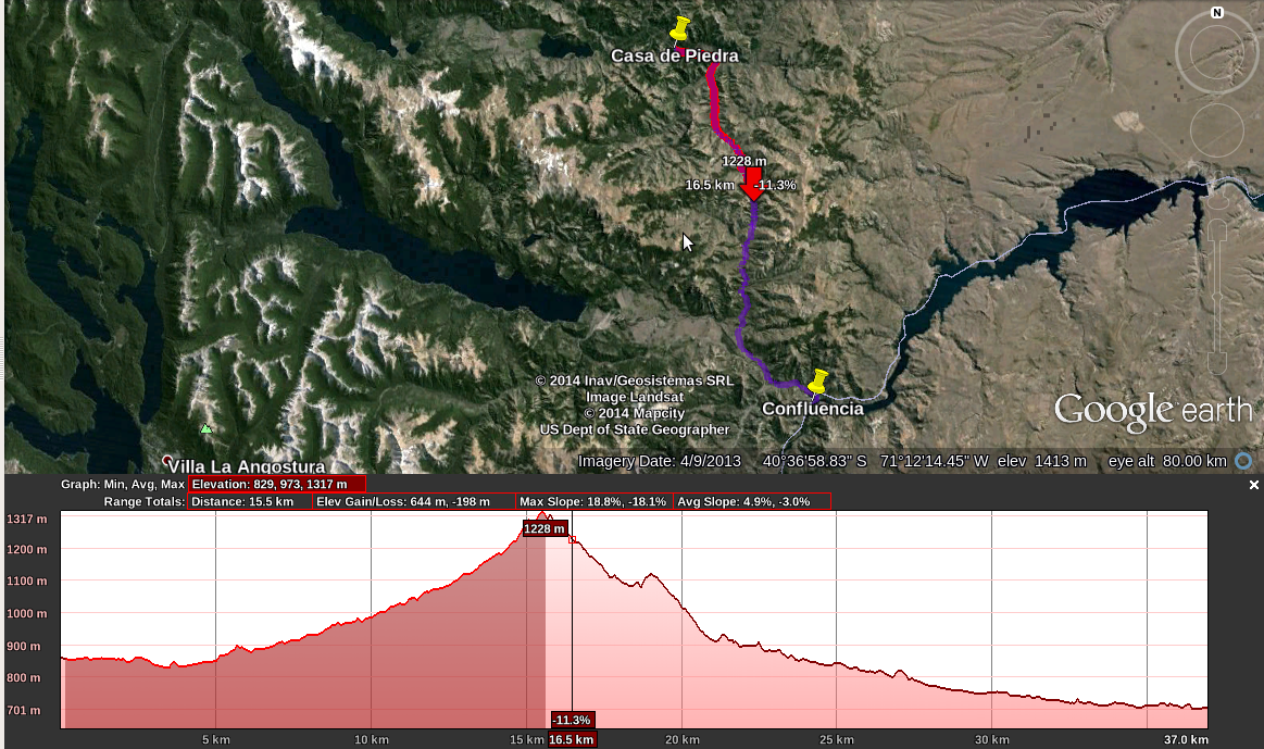 |
| Mapa del cuarto día, mostrando el perfil de elvacioń. Map of the fourth day, showing elevation profile plot. |
Mi idea para este viaje era hacerlo en cuatro días, el primero saliendo desde Confluencia hasta el final del lago Traful, donde me habían dicho que había un camping agreste (Puerto Arraya). El segundo día pensaba pedalear por la ruta de los Siete Lagos y buscar algún camping en el camino, más o menos a mitad de viaje entre Puerto Arrayán y Villa Meliquina. El tercer día planeaba llegar a Meliquina, un pueblito al fondo del lago con el mismo nombre, también me habían comentado que era un lindo lugar. Y finalmente, el último día había que subir al Paso Córdoba y bajar hasta llegar a Confluencia de nuevo.
El viaje salió bastante bien, mejor que el primero, sobre todo porque pude completar lo que tenía planeado, y casi sin lesionarme (alguna molestia en la rodilla izquierda esta vez, calculo que fue culpa del asiento un poco bajo, pero no estoy seguro).
Los días transcurrieron más o menos así:
Primer dia, Confluencia - Puerto Arrayán: Unos 51 km sin demasiado desnivel, dia soleado sin mucho viento, algo caluroso pero no molestaba para pedalear. Lindo paisaje en esta zona, al principio es bastante árido, pero a medida que uno va avanzando hacia el oeste se empieza a ver todo más verde. Por momentos se va bordeando el río Traful, hasta llegar a la margen este del lago Traful, donde comienza el pueblo de Villa Traful (si, todos con el mismo nombre). A partir de ahí, se sigue bordeando el lago por el sur, hasta llegar a la margen oeste (en realidad, es uno de los brazos, otro sigue hacia el noroeste) donde está el camping de Puerto Arrayán. En el medio hay varias playas y campings para disfrutar del lago.
Después de un rato de pedalear, llegué a Puerto Arrayán, más o menos temprano para armar la carpa sin apuro, comer algo, meterme al lago, cenar y a descansar un poco. A todo esto, era principios de enero, temporada alta de vacaciones, así que mucha gente en el camping, se ve que es bastante popular la ruta de los Siete Lagos… En total, unas cuatro horas de pedaleada (sin contar los descansos).
Segundo día, Puerto Arrayán - Lago Villarino: El segundo día amaneció con algo de lluvia, un poco más nublado, y bueno, será cuestión de arrancar total seguro no va a llover mucho... O eso esperaba yo, cada vez era más fuerte la llovizna hasta que ya era lluvia directamente, así que me puse la campera impermeable y a pedalear nomás, no hay mucha opción… Para este día no había hecho muy bien los deberes, estaba convencido que la subida más dura era la del Paso Córdoba, pero para ir desde Puerto Arrayán hasta empalmar la ruta de los Siete Lagos hay que trepar bastante, esta subida estuvo dura, sobre todo con la lluvia agregada…Una vez en la ruta de los Siete Lagos ya fue un poco mejor la pedaleada.
Después de un rato de pedalear, llegué a Puerto Arrayán, más o menos temprano para armar la carpa sin apuro, comer algo, meterme al lago, cenar y a descansar un poco. A todo esto, era principios de enero, temporada alta de vacaciones, así que mucha gente en el camping, se ve que es bastante popular la ruta de los Siete Lagos… En total, unas cuatro horas de pedaleada (sin contar los descansos).
+Puerto+Arrayan+CHICO.jpg) |
| Puerto Arrayán en invierno, lago Traful. Puerto Arrayan in winter, Traful lake. |
Segundo día, Puerto Arrayán - Lago Villarino: El segundo día amaneció con algo de lluvia, un poco más nublado, y bueno, será cuestión de arrancar total seguro no va a llover mucho... O eso esperaba yo, cada vez era más fuerte la llovizna hasta que ya era lluvia directamente, así que me puse la campera impermeable y a pedalear nomás, no hay mucha opción… Para este día no había hecho muy bien los deberes, estaba convencido que la subida más dura era la del Paso Córdoba, pero para ir desde Puerto Arrayán hasta empalmar la ruta de los Siete Lagos hay que trepar bastante, esta subida estuvo dura, sobre todo con la lluvia agregada…Una vez en la ruta de los Siete Lagos ya fue un poco mejor la pedaleada.
Después de unos 43 km y algo de tres horas y media de pedaleada llegué al camping del lago Villarino, que está al lado del Falkner. La idea era parar en el camping agreste y comer unos fideos con queso, pero me terminó convenciendo el guiso que tenían en el camping, y la ducha caliente. La parte no tan buena es que había mucha gente en el camping, así que bastante ruido a la noche. Además se me había pinchado el aislante inflable (detalle de los aislantes inflables), pero con el cansancio que tenía no importó demasiado. Al otro día, me acordé que tenía parches y pegamento para la bicicleta, ¿funcionará para el colchón? Y, con probar no se pierde nada, y funcionó nomás, así que fue una sola noche de dormir en el piso…
 |
| Lago Villarino (foto por viajandoConOlmo, parece que también le gusta viajar en bicicleta). Villarino Lake (photo by viajandoConOlmo, it seems he also likes to travel by bike). |
Tercer dia, Puerto Arrayán - Casa de Piedra: Por suerte mejoró el clima, sin lluvia y más o menos despejado. A pedalear de nuevo, a esta altura la ruta está asfaltada, así que iba bastante bien la pedaleada. Después de algunos kilómetros, llego al desvío que va a Villa Meliquina, acá empezaba la parte desconocida del viaje. De vuelta al camino de tierra, un poco serruchado por momentos, por suerte la pila de cosas que cargaba aguantó bastante bien. A eso del mediodía llego a Meliquina, paso por la oficina de Turismo a ver si consigo un camping. Ahí me informa que unos kilómetros más adelante, a la orilla del río, hay un camping agreste llamado Casa de Piedra. No estaba muy cansado, así que aproveché para comprar algo de comida y seguir pedaleando un poco más. Me acerco a una de las despensas del pueblo para comprar algo de fruta y verduras, que ya estaba extrañando, un yogurt también ya que estamos, y no se si me vieron con hambre o muy flaco, la cosa que la dueña me ofrece un poco de asado, a lo que no pude decir que no, claramente…
Después de bajar un poco la comida, sigo pedaleando sin mucho apuro hasta llegar al campamento Casa de Piedra, se ve que es bastante popular porque había mucha gente por el día, algunos pescando con mosca y otros simplemente disfrutando del río, muy lindo lugar por cierto… Al atardecer, ya con la carpa armada, me dispongo a comer los fideos de todos los días, la gente ya estaba partiendo, no había ninguna otra carpa, así que creí que iba a estar solo esta noche, cuando de repente caen dos camionetas, tres familias en total, ahí nomás arman las carpas y empiezan a hacer un asado, mientras yo degustaba mis “exquisitos” fideos… Se ve que de nuevo tenía mucha cara de hambre, porque otra vez me invitaron a comer asado, y bueno, no es cuestión de despreciar... Así que un poco de charla, asado y vino con los vecinos, y a dormir un rato, que mañana queda lo mejor: La subida del Paso Córdoba. En total, 54 km en tres horas y media de pedaleada.
 |
| Camping agreste Casa de Piedra, vista 360 grados acá. Wild camp Casa de Piedra, 360 degree here. |
Cuarto dia, Casa de Piedra - Confluencia: Otro día más de bicicleta. Me levanto sin mucho apuro, ya es casi una rutina lo de desarmar el campamento y cargar todo en la bici, uno ya le va agarrando la mano y sale todo más rápido, más fácil. Empiezo a pedalear hacia el Paso, la subida más dura, según mis planes. Después de algunos kilómetros llego a la trepada, bastante sostenida, pero, ante mi sorpresa, me resulta menos complicada que la subida del segundo día, se nota que la ruta tiene otro diseño, la pendiente es bastante constante durante toda la subida, en cambio la subida desde Puerto Arrayán a la ruta de los Siete Lagos tenía secciones más empinadas y secciones un poco más planas. Quizás también tiene que ver el terreno, acá parece haber más lugar para “dibujar” la ruta, claro que todo esto son solo especulaciones porque no soy ingeniero civil ni mucho menos.
Cuestión que después de algunos kilómetros de subida sostenida, llego al punto más alto del Paso. Me paro un rato a contemplar el paisaje, hay un poco de viento, y hacia el oeste se ven venir unas nubes que me hacen acordar al segundo día… En eso estaba, cuando miro para el otro lado y veo venir otra bicicleta, asomando atrás de la última cuesta del Paso... Nos saludamos en el punto más alto del dia, como si nos conociéramos desde siempre, es un tanto extraño el sentimiento de hermandad que se forma casi instantáneamente entre dos desconocidos que comparten los mismos gustos, en este caso el de viajar en bicicleta (aunque lo mismo suele pasar cuando ando caminando por la montaña), ¿Tendrá que ver con la necesidad del ser humano de compartir el mismo sentimiento con alguien más? Después de intercambiar información sobre el recorrido (qué hay para cada lado, adónde dormir, etc), nos despedimos para seguir cada uno por su lado, dale que no hay mucho tiempo antes de que se venga el agua de nuevo.
Ya queda poco, casi todo bajada y algunos kilómetros planos cerca de Confluencia. Hasta que, casi de improvisto, escucho una explosión, e instantáneamente se desinfla la rueda trasera. Raro, uno esperaría que se pinche, pero no que explote, quizás tuvo que ver la inflada de más que le di antes de salir, con la idea de que mientras más inflada la cubierta más fácil pedalear. Resulta que no solo se rompió la cámara, sino que la cubierta también está rota, lo que hizo que la cámara toque el aro de metal y se rompa directamente, nada de pinchaduras... Pruebo de cambiar la cámara, quizás con menos presión aguante… Y aguanta, un kilómetro, y se pincha también, así que a caminar, no hay más cámaras de repuesto. Por suerte ya estoy cerca, algo de 4 o 5 km. Quizás no era mala idea una cubierta de repuesto, aunque en realidad la cubierta no era de muy buena calidad, ya la tenía que cambiar hace rato, tarea para la vuelta… Después de una media hora de caminata, llego a Confluencia, fin del viaje, casi que pude pedalear todo, quedará para la próxima, cuestión de seguir mejorando, aprendiendo de los errores. En total el último día, 36 km en dos horas y media, de los cuales más o menos 4 km caminando.
 |
| Paso Córdoba, no había nieve cuando pasé yo (foto por Ya Calderoń ya). Paso Cordoba, there was no snow when I pass by (photo by Ya Calderoń ya). |
Total del viaje, unos 187 km en cuatro días, con un poco de sol, viento, lluvia, subidas y bajadas. Muy buena la pedaleada, a seguir entrenando y planear la próxima!
I’ve already done most of the route by car, except for the Meliquina and Córdoba Pass stretch. The idea was to pedal 40 or 50 km per day, more or less the distance I was targeting in training. I also tried to reduce the amount of carried stuff, the photo camera was between the things I left, so no actual pictures of this trip...
I used Google Earth software during the planning of the trip. It has an interesting function that allows us to draw a path in the map and look for distances and elevations. First, you have to mark the path using the button “Add Path” , which adds our path to the left bar “Places”. Then, if we right click the path and select “Show Elevation Profile”, a plot opens up showing information of distance, height and slopes of the selected path. This information is useful in order to estimate the distance traveled by day, how would be the climbs and descents, where to sleep in order to distribute the total distance in the available days, etc.
The plan for the trip was to do it in four days, the first one starting at Confluencia until the end of Traful lake, where I’ve been told it was a wild campsite (Puerto Arrayan). The second day I should travel through Seven Lakes road searching for a camping in between Puerto Arrayan and Meliquina. I was planning to arrive to Meliquina the third day, a little town at the end of the lake with the same name, I’ve also been told that it was nice. And finally, the last day I should go up Córdoba Pass and down again until getting to Confluencia.
The trip went out pretty well, better than the first one, mainly because I could make it up to the end, almost uninjured (my left knee hurt a little, maybe because of the sit’s wrong height, but I’m not sure)
The days went by more or less like this:
First day, Confluencia - Puerto Arrayan: About 51 km more or less flat, sunny day without too much wind, a little bit hot but tolerable. I like this zone landscape, kind of dry and desertic at the start and it keeps turning more and more green as you move towards the west. The road goes besides the Traful river at some time, then you get to the east coast of Traful lake, where the Traful Village starts (yes, all share the same name). From there, you keep traveling by the lake’s south coast until arriving to the west coast (there’s also another arm that goes north-west), where lies Puerto Arraryan camp. In the middle you can found some beaches and camp sites to enjoy the lake. After some pedaling, I got to Puerto Arrayán, with some time to mount the camp, eat something, swim in the lake, have a dinner and rest. It was beginning of january, high season vacations, so the camp was really full of people, it seems this is a popular place… All in all, about four hours of biking (without counting rests).
Second day, Puerto Arrayán - Lago Villarino: This day was more cloudy, started up with some light rain, so well, its time to ride the bike, sure it gets better… Or that’s what I hoped, because the light rain was only increasing until becoming real rain, so I took out the rain jacket and continue pedaling, it’s the only option… I haven’t look the map very well for this day, I thought that the toughest climb was the one at Paso Córdoba, but it seems there is an interesting climb if you want to go from Puerto Arrayan to the Seven Lakes route, this was a tough one, I think the rain also helped to this purpose… The biking showed some improvement once in the Seven Lakes road.
After about 43 km, and something like three and a half hour, I got to Villarino lake camping, it’s besides Falkner lake. The idea was to camp in the latter (a wild camp) to eat some pasta with cheese, but I got convinced by the stew on the camping, along with the hot bath. The flip side of the camping was the crowd, a lot of noise at night. Moreover, I have punctured my inflating sleeping pad (minor details of inflated pads), but I was so tired that it didn’t mattered. The next day I recalled that I was carrying patches and glue, will this work for the pad? I should try, just in case, and it worked, so in the end it was only one night of sleeping in the floor.
Third day, Puerto Arrayán - Casa de Piedra: The weather was better this morning, no rain and more or less clear. So biking again, through a paved road in this part or the route, so the pedaling was going smooth. After some kilometers, I turn right to head Meliquina Village, heading to the unknown. Unpaved road again, with some holes in it, at least this time everything was tied tight. I get to Meliquina about midday, and stop by in the tourism office searching for a place to camp. It seems there is a campsite some km’s ahead, next to the river, named “Casa de Piedra” ("stone house" or something like that). I pass by a grocery store in order to get some fruits, that I’m already missing, some yogurt also, and I don’t know if I looked too skinny or hungry, because they offer me some barbecue, which I couldn’t resist...
After some time for digestion, I continue biking without hurry until I got to Casa de Piedra camping, telling by the amount of people there it seems is a popular place, some are fly fishing and others just enjoying the river, nice place for sure… At dusk, with the camp already set up, I’m ready to cook some pasta, everybody has left so I think I’m going to be alone this night, but out of a sudden two vans arrived, totalling three families, they set up their camp and start preparing an “asado” (barbecue), while I look at my “delicious” pasta… It seems that I still look like hungry,
because the invite me to join them, a proposal I couldn’t refuse… So after some chat, meat and wine with the neighbours, it’s time to sleep, tomorrow awaits the best part of the trip: Paso Córdoba climb. Total of the day, about 54 km in three hours and a half.
Fourth day, Casa de Piedra - Confluencia: Another biking day. I get up with no hurry, this thing of dismounting the camp and loading the bike is almost a routine by now, you get used to it, everything goes quickly, easier. I start pedaling toward the pass, the toughest climb, according to the planning. I get there after some kilometers, the climb is sustained, but to my surprise I find it less complicated that the climb on the second day, it seems the rout has a different design, the slope is steady through all the distance, in contrast to the climb from Puerto Arrayan to Seven Lakes road which had a mix of steep and flat sections. Maybe all this is related to the landscape, there is more space here to “draw” the road line, but this are just speculations, I’m not a civil engineer.
So, after some km’s of continuous climb, I get to the pass highest point. I stop to stare at the view, there’s some wind blowing, and some fat clouds at the west, and approaching, what reminds me two days ago… I was immersed in this thoughts when I look to the other side on the climb and see another bike coming up behind the slope… We greet in this day’s highest point, almost like if we knew each other since a long time, it’s kind of weird this brotherhood feeling you sometimes get with an unknown who shares your same interests, in this case, traveling by bike (but the same use to happen to me also while walking in the mountain), It would be related to some kind of need of the humankind to share the same feelings with someone else? After changing some thoughts about the route (what’s to that side, and this side, where to sleep, etc), we say goodby, and everyone continues through his side, come on that’s not to much time left before the storm settles down...
I’m almost there, mainly descent, and some flat km’s near Confluencia. And then, all of a sudden, an explosion, and the back wheel get’s flat almost instantly. This is rare, I’ll expect a puncture, but an explosion? May be this is related to the last inflate this morning, with the idea that is easier to pedal with a well inflated tire. It turn out that it’s not only the tube broken, but also the tire, which made that the ring started touching the tube until finally broke it, no punctures here… Let’s try the spare tube, maybe it holds… And it holds, for about one kilometer, and it also breaks, so time to walk, no more spare tubes. At least I’m near Confluencia, about 4 or 5 km. May be it wasn’t a bad idea to carry a spare tire, but the thing was that I knew that tire was about to brake, not very good quality, so now I have my homework to do… I get to Confluencia after about half an hour of walking, end of the trip, I biked it almost all, let’s see the next time, now it’s time to do some improvements, learning from the errors. All in all the last day, 36 km in about two and a half hours, from which I walked about 4 km.
Balance of the trip, about 187 km in four days, with some sun, wind, rain, uphills and downhills. Very good trip and biking, let’s keep on training for the next one!
No hay comentarios.:
Publicar un comentario