 |
| Cerro Bella vista, saliendo desde el Tambo, accediendo a la pala SE desde la cumbre (imagen Google Earth) Bella Vista, starting at the Tambo, getting to the SE bowl across the summit (Google Earth image) |
 |
| Vista desde arriba, norte hacia arriba (imagen Google Earth) View from above, North up (Google Earth image) |
- La senda comienza por acá: Lat -41.1266868 deg, Lon -71.4611019 deg.
- Distancia y desnivel aproximado: 5 km (10 km ida y vuelta), 1200 m de subida (900 m hasta la cumbre, 300 m de bajada por la cara SE)
- Máxima pendiente aproximada: 25-30 grados
- Altura inicial: 850 m.s.n.m.
- Altura inicial: 850 m.s.n.m.
- Breve descripción: La senda comienza en El Tambo, que es el comienzo de la picada al refugio Jakob / General San Martín, a 500 metros de la ruta. Tomar la senda al refugio Jakob por unos 400, donde se bifurca, tomar a la derecha hacia el cerro Bella Vista. Seguir el sendero, que tiene algunas marcas, el cual va siempre en subida, siguiendo un filo de orientación ENE por dentro de un bosque alto. La pendiente va siempre en aumento, hasta que se sale del bosque a unos 1500 m.s.n.m., unos 100 m más arriba se llega a la precumbre, donde cambia la pendiente. Desde la precumbre, continuar por el filo que lleva a la cumbre, en dirección OSO. Una última subida nos lleva a la cumbre de unos 1800 m.s.n.m., desde la que se puede acceder a la cara SE, donde hay una buena bajada hasta el comienzo de la vegetación, alrededor de 1500 m.s.n.m.. Es recomendable volver por el mismo camino.
- Start from here: Lat -41.1266868 deg, Lon -71.4611019 deg.
- Approximate distance and climb: 5 km (10 km round trip), 1200 m climb (900 m to the summit, 300 m down the east slope)
- Approximate Max slope angle: 25-30 deg
- Starting elevation: 850 m.a.s.l.
-
Brief description: The trail starts at "El Tambo", which is also the start of the trail to Jakob / General San Martín hut, at about 500 meters from the road. Take the trail to the hut for about 400 m, where there is a bifurcation, take right towards Bella Vista. Follow the trail, which has some marks on it and always goes up, through an ENE ridge, inside a tall forest. The slope angle gets progressively steeper, the trail gets out of the forest at about 1500 m.a.s.l. and about 100 m more you get to a slope change, the presummit. From here, continue through the ridge which takes you to the summit, WSW direction. A final climb leads to the summit at about 1800 m.a.s.l., from where you can access the SE face, with a good skiing until the start of the vegetation, at about 1500 m.a.s.l. For the way back, it's recommended to undo the same path.
Back to the list
 |
| La nieve empieza a asomar en el filo ENE, a eso de una hora desde el Tambo The snow starts to show up in the ENE ridge, about an hour from the Tambo |
 |
| Vista desde la precumbre, el filo de la izquierda lleva a la cumbre, la cara SE no se ve desde acá. A la derecha, el López, entre las nubes. View from the presummit, the ridge at le let leads to the summit, SE face is not visible in this picture. López hill to the right, between the clouds. |
 |
| Vista desde la cumbre hacia Bariloche y el lago Nahuel Huapi, se ve la precumbre abajo a la derecha View from the summit towards Bariloche and Nahuel Huapi lake, the presummit is visible down to the right |
 |
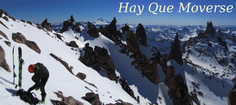
| La pala SE en condiciones primaverales, la cumbre arriba a la derecha The SE bowl in good spring conditions, summit in the top right |
No hay comentarios.:
Publicar un comentario