 |
| Valle del Challhuaco y subida a la cumbre (dos opciones), también se ven los cerros Blanco y Ñireco (imagen Google Earth) Challhuaco valley and the way up to the summit (two options), Blanco and Ñireco hills are also visible (Google Earth image) |
 |
| Vista desde arriba, norte hacia arriba (imagen Google Earth) View from above, North up (Google Earth image) |
- La senda comienza por acá: Lat -41.2580994 deg, Lon -71.2850851 deg.
-
Distancia y desnivel aproximado: 5 km (10 km ida y vuelta), 750 m de
subida
- Máxima pendiente aproximada: 15-20 grados
- Altura inicial: 1300 m.s.n.m.
- Altura inicial: 1300 m.s.n.m.
-
Breve descripción: La senda comienza en el refugio Neumeyer, en el valle del Challhuaco. Desde el refugio, tomar la senda de verano a la cumbre, que sube por el bosque alto en dirección SO. La senda está marcada con señales amarillas reflectantes sobre los árboles. Luego de unos 1.5 km, se abren un par de opciones:
1) Continuar la senda de verano, hacia la izquierda, dirección S, cruzando un pequeño arroyo. Se pasa por un claro en el bosque, de unos 100 metros de largo, para luego volver a entrar en el mismo. Finalmente el bosque se torna más bajo y se puede apreciar la cumbre y la cara este del cerro Challhuaco. Continuar hacia la cumbre por un lomo bastante ancho, de orientación ENE.
2) En lugar de cruzar el arroyo a la izquierda, continuar en dirección OSO. En breve se sale del bosque para ganar un lomo de orientación E, ubicado al norte del lomo de la opción 1). Desde aquí se observa la cara este del Challhuaco y su cumbre. Continuar por el lomo y la cara este en dirección hacia la cumbre.
- Start from here: Lat -41.2580994 deg, Lon -71.2850851 deg.
- Approximate distance and climb: 5 km (10 km round trip), 750 m climb
- Approximate Max slope angle: 15-20 deg
- Starting elevation: 1300 m.a.s.l.
- Starting elevation: 1300 m.a.s.l.
-
Brief description: The trail stars at Neumeyer's hut, in Challhuaco's valley. From the hut, take the summer trail to the summit, which goes up through a tall forest in SW direction. The trail is marked with yellow reflective signs in the trees. After about 1.5 km, you have a couple of options:
1) Continue following the summer trail, to the left, S direction, crossing a small river. You get out of the forest for about 100 m, and then in again. Finally, the forest get smaller and you can see the summit and the east face of Challhuaco. Continue to the summit through a wide ridge of ENE orientation.
2) Instead of corssing the small river to the left, continue in WSW direction. In a short time you are out of the forest, gaining an E facing ridge, to the north of the ridge of option 1). From there you can see the east face of Challhuaco and its summit. Continue through the ridge and east face towards the summit.
Back to the list
 |
| Saliendo del refugio temporario, después de que el original fuera destruido por un incendio. Starting at the temporary hut, after the original one was destroyed by a fire. |
 |
| Un claro en el bosque, antes de volver a entrar en él, siguiendo la opción 1). Se ve la cumbre arriba a la derecha. A short opening in the forest, before getting out again, following option 1). The summit is visible in the top right |
 |
| Foqueando hacia la cumbre, sobre el filo ENE, opción 1) Skinning the way up to the summit, in the ENE ridge, option 1) |
 |
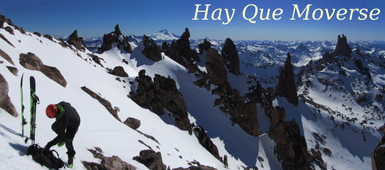
| Vista desde la cumbre hacia el SO. A la derecha se ve el filo que une el Challhuaco con el cerro Blanco, y más a la derecha, el cerro Ñireco. View from the summit, SW direction. To the right, the ridge between Challhuaco and Blanco hills is visible, and also Ñireco hill. |
No hay comentarios.:
Publicar un comentario