Siempre me gusto esquiar, desde la primera vez que me puse un par de esquíes hace más de veinte años. Pero yo vivía en La Pampa, así que mi mundo del esquí estaba limitado a algunos días al año en el centro de esquí de Las Leñas (Mendoza) y el Cerro Bayo (Villa La Angostura, Neuquén). A veces en Las Leñas veía los carteles de "peligro" al principio de alguna bajada fuera de pista, incluso llegué a esquiar algunas, pero nada demasiado alejado de las pistas.
Después me mudé a Bariloche (en 2010) y leí un artículo de Sebastián de la Cruz donde contaba que había esquiado desde la cumbre del monte Tronador, que en realidad es un volcán. En ese momento, me parecía imposible si quiera llegar a la cumbre del tronador, no tenía el equipo, ni el entrenamiento ni (lo más importante) las habilidades necesarias para subir hasta ahí, así que mucho menos para esquiar una pendiente de 45 grados.
Pero este artículo fue como una inspiración, mostrandme que las cosas que a veces parecen imposibles no lo son tanto. Esto no quiere decir que cualquiera puede ir a esquiar desde la cumbre del Tronador, es Sebastían de la Cruz el que está hablando acá...
De todas formas, la idea de esquiar desde la cumbre de los volcanes me quedó dando vueltas en la cabeza. Durante las siguientes temporadas de esquí, después de llegar a Bariloche, aprendí un poco sobre esquí de montaña, escalada en hielo y transito glaciar. También empecé a salir más seguido a las montañas, ya que me quedaban más cerca.
Finalmente el invierno pasado (2015) tuve el privilegio de poder esquiar algunos volcanes que venía mirando hace algunos años, entre ellos el Lanín y el Osorno. También esquié el Casablanca (todos desde la cumbre) y la mayor parte del Puntiagudo. Hay muchos volcanes cerca de Bariloche, así que la lista es casi infinita, acá elegí algunos, incluyendo algunos que esquié y otros que espero esquiar en el futuro: Lanín, Osorno, Casablanca / Grupo Antillanca, Tronador, Puntiagudo, Puyehue, Villarrica, Mocho / Choshuenco, Llaima y Lonquimay.
I've always likes skiing, since I first step on a pair of skis more than 20 years ago. But I used to live in the flat lands, so my skiing world was limited to the in bound area of Las Leñas (in Mendoza) and Cerro Bayo (in Villa La Angostura, Neuquén). Sometimes in Las Leñas I saw the "warning" signs at the beginning of some out of bounds run, I even took some of them, but nothing really far away from the pistes.
Lanín
El volcán Lanín es una montaña especial para mi. De alguna manera, fue la primer montaña importante que traté de subir. Fuimos con mi amigo Cristian y un guía en el verano de 2009. La idea era caminar a la cumbre por la ruta normal, nada de esquíes esta vez. Yo tenía muy poca experiencia caminando arriba de la nieve o el hielo, y mi amigo estaba en una situación similar. Llegamos al área de acampe según lo previsto, pero al otro día había mucho viento y tuvimos que bajar. Esa noche no pude dormir, quizás por el viento que soplaba (bastante), o la ansiedad, o las dos cosas.
Algunos años después volví al Lanín a principios de noviembre. Fuimos hasta la cumbre con Martín, en una salida por el día. Otra vez había viento, y frío, pero pudimos disfrutar de la caminata hasta la cumbre, donde no hubo mucho tiempo para mirar el paisaje: Dos fotos y "salgamos de acá".
En agosto pasado fui de vuelta al Lanín, con Matías, esta vez en invierno, a ver si encontrábamos buena nieve para esquiar. La idea era subir en dos días, durmiendo en el refugio RIM. Había nevado la noche anterior, así que nos pusimos los esquíes literalmente al lado del auto. Subimos con las pieles sin mucho apuro, a las de Matías se le pegaba la nieve, y en el filo había un poco de viento, así que llegamos al refugio justo al atardecer.
Al otro día arrancamos hacia la cumbre a eso de las 4 am, subiendo con las pieles de foca durante unas dos horas, hasta que la nieve dura y la pendiente que se incrementaba nos hicieron cambiar por crampones. Llegamos a la cumbre a eso del medio día, yo llevaba los esquíes, ya que tenía la intención de esquiar desde la cumbre, mientras que Matías los dejo más abajo en "el plató", a unos 3000 m.s.n.m.
En la cumbre soplaba el viento, de nuevo, pero por lo menos esta vez nos podíamos reparar atrás de una pared de nieve. La nieve cerca de la cumbre tenía unas formaciones bastante grandes del estilo "alas de ángel", así que la esquiada fue en "modo supervivencia", durante las primeras vueltas.
Después de bajar algunos metros, llegué a la parte más empinada de la bajada, el lugar donde claramente no te querés caer. Había dado una vuelta más de lo necesario, así que tenía dos opciones: Un salto hacia la izquierda (de algo más de un metro), o bajar derecho por un pasaje angosto para frenar más abajo. Fui por la segunda opción, para evitar el salto.
Todo venía según lo planeado, hasta que intenté frenar, parece que la fuerza en las fijaciones fue demasiado y una fijación se saltó, dejándome con un solo esquí y deslizando cabeza abajo por la pendiente. Ahí me acorde de la maniobra de autodetención, ¿cómo era esto? Ah, primero la cabeza para arriba, OK, ahora pararse en las manos y los pies, por suerte funcionó, sobre todo gracias a que tenía un solo esquí y que la nieve estaba blanda.
Después de frenarme, me fijé que todas las partes del cuerpo estuvieran en su lugar, parece que estaba todo bien; luego busqué el equipo, estaba todo, incluido el esquí que se salió, que estaba unos 10 m pendiente arriba. Esa fue una caída con suerte, pensé... Para la próxima bajada empinada, mejor ajustar un poco más la tensión vertical de las fijaciones (la tensión lateral se puede bloquear en el momento -NO recomendado por el fabricante-, pero en las fijaciones estilo Dynafit la tensión vertical solo se ajusta con los resortes).
Aparte de la caída, el resto de la bajada fue sin problemas. Buscamos los esquíes de Matías y continuamos camino abajo hacia el refugio. La nieve estaba entre mala y malísima (nieve dura y volada), pero eso era mejor que las piedras, en mi opinión. Después de un rato llegamos de vuelta al refugio, comimos algo, guardamos todo y continuamos con la bajada. Y ahí fue donde ocurrió la magia: En una cara este abajo del refugio, encontramos la mejor nieve del viaje (y de la temporada, en realidad), nieve en polvo apilada por el viento (si, no es lo mejor desde el punto de vista de las avalanchas). Incluso con la mochila pesada, ¡la bajada fue muy buena! Te diría que me quedé con ganas de volver a subir, quizás en el próximo viaje...
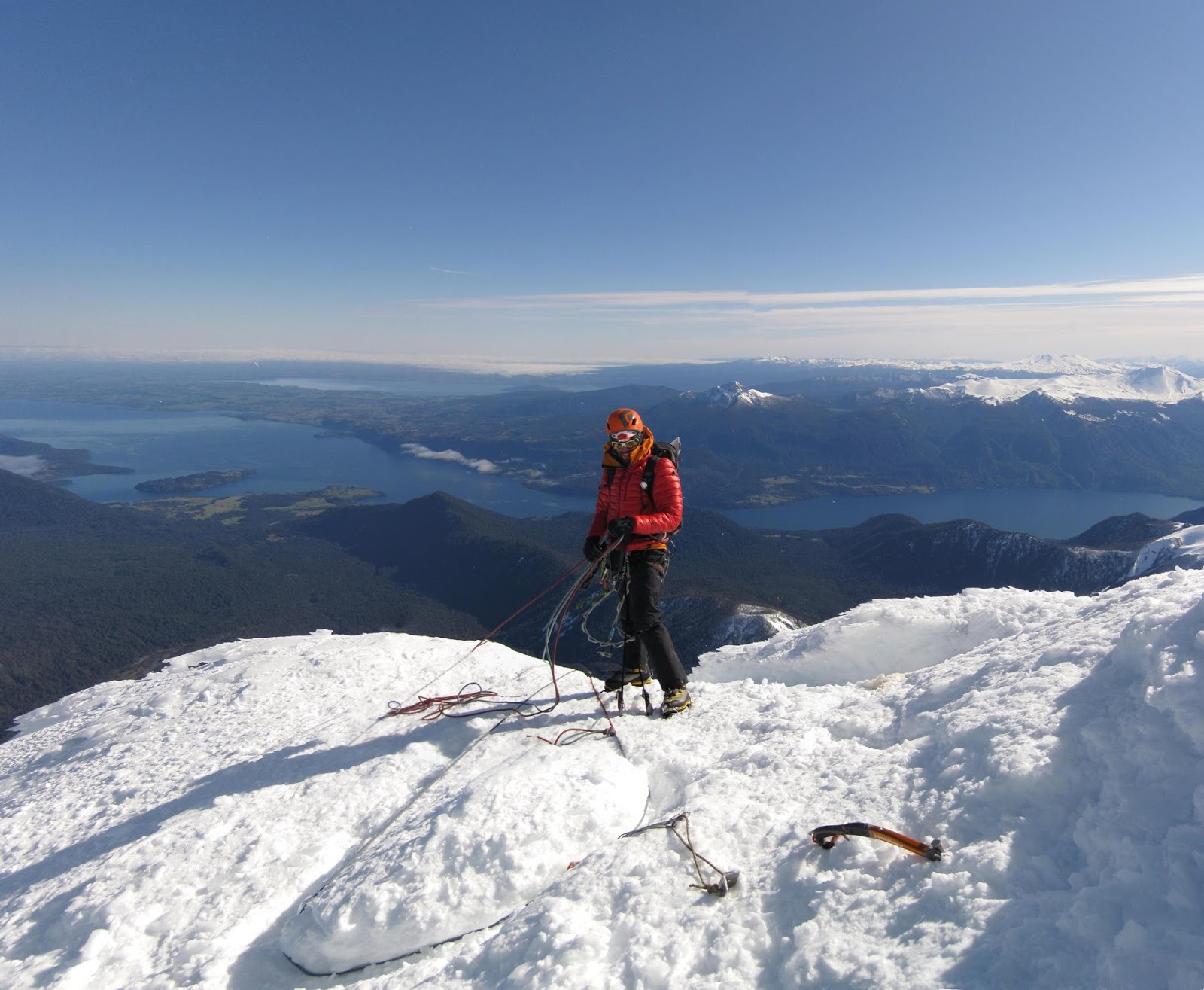
La esquiada desde la cumbre del Lanín es realmente larga, unos 2600 m de esquiada continua, no hace falta poner las pieles o caminar, casi una pirámide perfecta, ¡muy recomendable! Solo hay que acordarse de tener cuidado en la parte más empinada, mejor no caerse...
Después me mudé a Bariloche (en 2010) y leí un artículo de Sebastián de la Cruz donde contaba que había esquiado desde la cumbre del monte Tronador, que en realidad es un volcán. En ese momento, me parecía imposible si quiera llegar a la cumbre del tronador, no tenía el equipo, ni el entrenamiento ni (lo más importante) las habilidades necesarias para subir hasta ahí, así que mucho menos para esquiar una pendiente de 45 grados.
Pero este artículo fue como una inspiración, mostrandme que las cosas que a veces parecen imposibles no lo son tanto. Esto no quiere decir que cualquiera puede ir a esquiar desde la cumbre del Tronador, es Sebastían de la Cruz el que está hablando acá...
De todas formas, la idea de esquiar desde la cumbre de los volcanes me quedó dando vueltas en la cabeza. Durante las siguientes temporadas de esquí, después de llegar a Bariloche, aprendí un poco sobre esquí de montaña, escalada en hielo y transito glaciar. También empecé a salir más seguido a las montañas, ya que me quedaban más cerca.
Finalmente el invierno pasado (2015) tuve el privilegio de poder esquiar algunos volcanes que venía mirando hace algunos años, entre ellos el Lanín y el Osorno. También esquié el Casablanca (todos desde la cumbre) y la mayor parte del Puntiagudo. Hay muchos volcanes cerca de Bariloche, así que la lista es casi infinita, acá elegí algunos, incluyendo algunos que esquié y otros que espero esquiar en el futuro: Lanín, Osorno, Casablanca / Grupo Antillanca, Tronador, Puntiagudo, Puyehue, Villarrica, Mocho / Choshuenco, Llaima y Lonquimay.
 |
| Viendo qué se puede esquiar en el volcán Puntiagudo, con Martín y el Pájaro Hopping to get some skiing in Puntiagudo volcano, with Martín and Pájaro |
I've always likes skiing, since I first step on a pair of skis more than 20 years ago. But I used to live in the flat lands, so my skiing world was limited to the in bound area of Las Leñas (in Mendoza) and Cerro Bayo (in Villa La Angostura, Neuquén). Sometimes in Las Leñas I saw the "warning" signs at the beginning of some out of bounds run, I even took some of them, but nothing really far away from the pistes.
Then I moved to Bariloche (in 2010) and I read an article of Sebastián de La Cruz who
skied from the top of Mount Tronador, which in fact is a volcano. At
that time, it seemed really far away for me just to step on top of
Tronador highest peak, I didn't had the equipment, training nor (most
important) the skills to get up there, never mind skiing down a 45
degree slope.
But this article sparked my imagination, showing that things that look impossible aren't so. This doesn't mean than anyone could go and ski Tronador, it's Sebastian de la Cruz here who is talking...
Nevertheless, the idea of skiing from atop of volcanos stayed in my mind. During the following ski seasons, after arriving to Bariloche, I learned about ski mountaineering, ice climbing and glacier travel. I also started to go out to the mountains more often, since they where closer.
Finally
this past winter (2015) I had the privilege to ski some volcanos I had
been watching since some years ago, namely Lanín and Osorno. I also
skied Casablanca volcano (all of them from the top) and most part of
Puntiagudo. There are a lot of volcanos near Bariloche, so the list is
almost endless, I've picked some of them, including some ones I've
skied and some others I'm hopping to do so: Lanín, Osorno, Casablanca /
Antillanca group, Tronador, Puntiagudo, Puyehue, Villarrica, Mocho /
Choshuenco, Llaima and Lonquimay.
Lanín
El volcán Lanín es una montaña especial para mi. De alguna manera, fue la primer montaña importante que traté de subir. Fuimos con mi amigo Cristian y un guía en el verano de 2009. La idea era caminar a la cumbre por la ruta normal, nada de esquíes esta vez. Yo tenía muy poca experiencia caminando arriba de la nieve o el hielo, y mi amigo estaba en una situación similar. Llegamos al área de acampe según lo previsto, pero al otro día había mucho viento y tuvimos que bajar. Esa noche no pude dormir, quizás por el viento que soplaba (bastante), o la ansiedad, o las dos cosas.
 |
| Volcán lanín, febrero 2012, poca nieve eh... Lanín volcano, February 2012, not so much snow... |
 |
| "¿Cómo fue esa subida Cabezón?", "Te prometo que para la próxima entreno, en serio" "How was that approach Cabezón?," "I promise you I'll train for the next one, seriously" |
Algunos años después volví al Lanín a principios de noviembre. Fuimos hasta la cumbre con Martín, en una salida por el día. Otra vez había viento, y frío, pero pudimos disfrutar de la caminata hasta la cumbre, donde no hubo mucho tiempo para mirar el paisaje: Dos fotos y "salgamos de acá".
 |
| Amaneciendo en Lanín, llegando a la canaleta, a unos 3200 m.s.n.m. Dawn at Lanín, getting to the "canaleta", at about 3200 m.a.s.l. |
 |
| Barridos por el viento, en la cumbre, con Martín Blown by the wind, at the summit, with Martín |
En agosto pasado fui de vuelta al Lanín, con Matías, esta vez en invierno, a ver si encontrábamos buena nieve para esquiar. La idea era subir en dos días, durmiendo en el refugio RIM. Había nevado la noche anterior, así que nos pusimos los esquíes literalmente al lado del auto. Subimos con las pieles sin mucho apuro, a las de Matías se le pegaba la nieve, y en el filo había un poco de viento, así que llegamos al refugio justo al atardecer.
 |
| ¿Vos decís que eso va a funcionar? Do you think that's going to work? |
 |
| El viento soplando un poco, en el filo hacia el refugio The wind picking up, in the ridge towards the hut |
 |
| El refugio RIM al atardecer (2300 m.s.n.m.) RIM hut at sunset (2300 m.a.s.l.) |
 |
| Llegando al refugio RIM, se viene la noche... Arriving to RIM hut, the night is coming... |
 |
| Subiendo por la canaleta, no está tan mal la nieve eh... Walking up the "canaleta", the snow isn't so bad eh... |
 |
| Otro grupo subiendo por la canaleta Another group going up through the "canaleta" |
En la cumbre soplaba el viento, de nuevo, pero por lo menos esta vez nos podíamos reparar atrás de una pared de nieve. La nieve cerca de la cumbre tenía unas formaciones bastante grandes del estilo "alas de ángel", así que la esquiada fue en "modo supervivencia", durante las primeras vueltas.
 |
| "Alas de ángel", cerca de la cumbre Rime ice formations, near the summit |
 |
| El otro grupo en la cumbre, buscando reparo del viento, volcán Villarrica de fondo The other group in the summit, sheltering from the wind, Villarrica volcano in the background |
Después de bajar algunos metros, llegué a la parte más empinada de la bajada, el lugar donde claramente no te querés caer. Había dado una vuelta más de lo necesario, así que tenía dos opciones: Un salto hacia la izquierda (de algo más de un metro), o bajar derecho por un pasaje angosto para frenar más abajo. Fui por la segunda opción, para evitar el salto.
Todo venía según lo planeado, hasta que intenté frenar, parece que la fuerza en las fijaciones fue demasiado y una fijación se saltó, dejándome con un solo esquí y deslizando cabeza abajo por la pendiente. Ahí me acorde de la maniobra de autodetención, ¿cómo era esto? Ah, primero la cabeza para arriba, OK, ahora pararse en las manos y los pies, por suerte funcionó, sobre todo gracias a que tenía un solo esquí y que la nieve estaba blanda.
Después de frenarme, me fijé que todas las partes del cuerpo estuvieran en su lugar, parece que estaba todo bien; luego busqué el equipo, estaba todo, incluido el esquí que se salió, que estaba unos 10 m pendiente arriba. Esa fue una caída con suerte, pensé... Para la próxima bajada empinada, mejor ajustar un poco más la tensión vertical de las fijaciones (la tensión lateral se puede bloquear en el momento -NO recomendado por el fabricante-, pero en las fijaciones estilo Dynafit la tensión vertical solo se ajusta con los resortes).
 |
| ¿Listo para la bajada? Creo que si... (foto por Matías) Ready for the descent? I think so... (photo by Matías) |
 |
| "Ehh, ¿no me alcanzás ese esquí, por favor?" "Ehh, can you pass me that ski, please?" |
 |
| Matías esquiando hacia el refugio. En el centro, cerro las Peinetas, atrás a la izquierda, volcán Llaima, y a la derecha, más atrás, el Lonquimay Matías skiing toward the hut. In the center, Las Peinetas hill, at the back left, Llaima volcano, and Lonquimay to the right, farther back. |
Aparte de la caída, el resto de la bajada fue sin problemas. Buscamos los esquíes de Matías y continuamos camino abajo hacia el refugio. La nieve estaba entre mala y malísima (nieve dura y volada), pero eso era mejor que las piedras, en mi opinión. Después de un rato llegamos de vuelta al refugio, comimos algo, guardamos todo y continuamos con la bajada. Y ahí fue donde ocurrió la magia: En una cara este abajo del refugio, encontramos la mejor nieve del viaje (y de la temporada, en realidad), nieve en polvo apilada por el viento (si, no es lo mejor desde el punto de vista de las avalanchas). Incluso con la mochila pesada, ¡la bajada fue muy buena! Te diría que me quedé con ganas de volver a subir, quizás en el próximo viaje...
 |
| ¡La mejor nieve de la temporada! ¿Vamos por otra vuelta? The best snow of the season! Let's go for another run? |
 |
| Volviendo al auto, literlamente una caminata de tres metros, después de 2600 m de bajada, no está mal... Getting back to the car, literally a three meter walk, after 2600 m of descent, not bad... |
La esquiada desde la cumbre del Lanín es realmente larga, unos 2600 m de esquiada continua, no hace falta poner las pieles o caminar, casi una pirámide perfecta, ¡muy recomendable! Solo hay que acordarse de tener cuidado en la parte más empinada, mejor no caerse...
Casablanca / Grupo Antillanca
En septiembre de 2012 fuimos con unos amigos en un viaje de esquí de montaña. La idea era subir al volcán Osorno y esquiar el volcán Casablanca, donde está el centro de esquí Antillanca. Estos dos volcanes están en Chile, cerca de Bariloche (unas cuatro horas de viaje hasta el centro de esquí en el volcán Osorno) .
Así que el sábado viajamos hasta el Casablanca, unas tres horas arriba del auto, incluyendo el cruce de la frontera con Chile. El lugar es muy lindo para hacer esquí de travesía, muchas laderas de pendiente moderada, algunos cráteres volcánicos para ver, el más grande tiene unos 700 m de diámetro. La cumbre del Casablanca está atrás del centro de esquí que se ve desde el estacionamiento.
Se suponía que este era un "día fácil" según nuestros planes, así que subimos con las pieles hasta la cumbre por el camino más directo que encontramos. La subida fue muy bien, salvo los últimos cien metros a la cumbre donde la nieve estaba un poco dura, ¡así que mejor no patinarse! (o sacarse los esquíes y caminar).
En septiembre de 2012 fuimos con unos amigos en un viaje de esquí de montaña. La idea era subir al volcán Osorno y esquiar el volcán Casablanca, donde está el centro de esquí Antillanca. Estos dos volcanes están en Chile, cerca de Bariloche (unas cuatro horas de viaje hasta el centro de esquí en el volcán Osorno) .
Así que el sábado viajamos hasta el Casablanca, unas tres horas arriba del auto, incluyendo el cruce de la frontera con Chile. El lugar es muy lindo para hacer esquí de travesía, muchas laderas de pendiente moderada, algunos cráteres volcánicos para ver, el más grande tiene unos 700 m de diámetro. La cumbre del Casablanca está atrás del centro de esquí que se ve desde el estacionamiento.
 |
| Todo listo para arrancar, en la base del centro de esquí Antillanca (foto por Guido) Getting ready to start, at Antillanca ski center base (photo by Guido) |
 |
| Subiendo por las laderas del centro de esquí Skinning through the ski center slopes |
 |
| El cráter más grande, camino a la cumbre (unos 700 m de diámetro) The biggest crater, in the way to the summit (about 700 m diameter) |
Se suponía que este era un "día fácil" según nuestros planes, así que subimos con las pieles hasta la cumbre por el camino más directo que encontramos. La subida fue muy bien, salvo los últimos cien metros a la cumbre donde la nieve estaba un poco dura, ¡así que mejor no patinarse! (o sacarse los esquíes y caminar).
Sacamos algunas fotos en la cumbre y bajamos esquiando. La nieve primavera en la cara oeste estaba en su punto justo para la bajada. Esquiamos el mismo camino que habíamos subido, que era un poco plano por momentos, y sin nieve en otros momentos, así que tuvimos que caminar un poco.
Volvimos hasta los autos y seguimos viaje hacia el Osorno, esta vez no pensaba esquiarlo desde la cumbre. Nunca había estado en el Osorno, pero Martín me contó que era una pendiente de nieve de unos 30 grados, que se pone cada vez más empinada hasta alcanzar unos 45-50 grados. La idea de escalar esa pendiente ya me resultaba un poco incómoda en ese momento, así que ni pensar en esquiarla... Pero eso es parte de la historia de otro volcán...
Osorno
Como venía diciendo, fui por primera vez al volcán Osorno en 2012. Aquella vez subimos con las pieles unas dos horas, hasta que tuvimos que cambiar por crampones porque la nieve estaba muy dura. Dejamos los esquíes en el cambio de pendiente (a unos 2400 m.s.n.m.) y escalamos la cara oeste más o menos derecho hasta la cumbre (a unos 2650 m.s.n.m.). Después de algunas fotos y de contemplar la vista, desescalamos algunos metros hasta los esquíes y bajamos esquiando hasta el auto (o casi, en realidad, tuvimos que caminar unos 200 m). La nieve no era perfecta, pero la esquiada estuvo buena. Sin embargo, la idea era esquiarlo desde la cumbre...
Así que volví al Osorno en septiembre de 2015, con un par de amigos, una especie de "repetición" del viaje anterior, ya que también esquiamos en Casablanca. Esta vez la nieve no estaba tan dura, pero la cara oeste tenía la misma inclinación y las mismas formaciones de "alas de ángel" (esta es la cara a barlovento), lo que complicaba esquiarla. Tenía la esperanza de encontrar una pasada por la cara norte o la este, para bajar de la cumbre, y después travesear hacia la cara oeste para continuar la bajada. La cara norte resultó ser menos empinada, pero también tenía alas de ángel, así que no encontré una pasada por ahí. En cambio, la cara este parecía tener buena nieve, así que decidí bajar algunos metros por ahí hasta que pudiera empalmar la cara norte (abajo de la línea de alas de ángel) y luego continuar hacia la cara oeste.
La nieve en la cara este era buena, incluso disfruté de un par de vueltas, después era el momento de empezar la travesía a la izquierda. Al principio iba todo bien, pero después la nieve se puso cada vez más dura, tuve que concentrarme bastante para no patinarme, frenase no iba a ser fácil. Parecía que si me patinaba no iba a parar hasta la linea de los árboles, unos 1400 m más abajo... Por momentos la nieve estaba más blanda y me podía relajar un poco.
Después de un rato, finalmente volví a la cara oeste, donde me encontré con mis compañeros, en el cambio de pendiente abajo de la cumbre. Ellos bajaron unos 400 m hasta el lugar donde habían dejado los esquíes, mientras que yo di un par de vueltas más en nieve dura y después (finalmente) la nieve se ablandó, así que me pude relajar un poco y disfrutar de la esquiada. Mientras más bajábamos, mejor la nieve, esa parte de la bajada estuvo muy buena.
Mirando un poco para atrás, esta fue la bajada en esquíes más dura que haya hecho, la travesía desde la cara este a la oeste estaba claramente en la categoría de "no vale caerse". Para la próxima, quizás un par de "whippets" no estarían mal. Según Google Earth, la pendiente máxima es de unos 33 grados, aunque me pareció un poco más empinado.
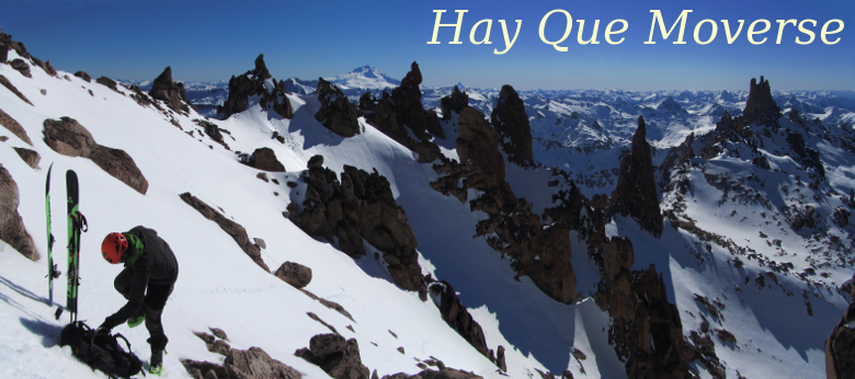
Puntiagudo
Este volcán se ve realmente interesante desde distintos puntos cerca de Bariloche, se ves desde el centro de esquí de Catedral, desde la mayoría de las cumbres de la zona, desde el volcán Osorno, etc. Tiene forma de pirámide hasta los metros finales, donde se pone más empinado, incluso parece "imposible" de subir.
Queríamos ir con unos amigos, pero parecía que nunca coincidían las condiciones del clima con nuestras agendas personales (la idea es ir ahí cuando está cubierto de nieve e hielo, preferentemente con un clima frío).
Finalmente, hace algunos meses, todo se alineó y partimos para allá a mitad de Septiembre, con Martín y el Pájaro. Según el pronóstico, viernes y sábado eran los mejores días, pero teníamos que trabajar, así que le apuntamos a la cumbre para el domingo. Hasta el sábado las temperaturas eran buenas (la isoterma de cero grados abajo de 1200 m.s.n.m.), el domingo la temperatura iba a subir un poco, según el pronóstico, y después de eso parecía que ya llegaba la primavera, así que este era probablemente EL fin de semana de la temporada. Además, en una semana, yo me iba de viaje por trabajo por un mes, así que había pocas chances de que el Puntiagudo estuviera en condiciones para fin de Octubre.
El viernes, viajamos hasta el comienzo de la picada (las cabañas de Robin), dormimos ahí, y el sábado empezamos la caminata de aproximación. Hubo alguna discusión entre si llevar esquíes o no: Martín creía que no hacían falta, yo quería esquiar, así que prefería llevarlos, y el Pájaro estaba indeciso. Finalmente, yo fui con esquíes y Martín y el Pájaro fueron caminando (Martín llevó un par de raquetas de nieve, que finalmente no hicieron falta). Al final, la diferencia de tiempo de marcha entre llevar o no esquíes fue despreciable, tanto en la subida como en la bajada, principalmente porque la nieve no estaba muy honda y algunos escaladores había abierto huella los días anteriores (subieron a la cumbre el viernes y el sábado).
El camino transcurre por la selva valdiviana durante unos 7 km, donde se llega a la base del volcán. Desde ahí seguimos subiendo un par de horas hasta que llegamos a un lugar para acampar, a unos 1500 m.s.n.m.. El Puntiagudo no es de los volcanes más altos (unos 2500 m.s.n.m.), pero la senda arranca a unos 200 m.s.n.m., así que el desnivel no es despreciable, con unos 2300 m en total. En el lugar de acampe nos encontramos con unos chilenos, dos de ellos habían subido a la cumbre el viernes, y ya estaban bajando, así que aprovechamos para usar el lugar para la carpa que ellos habían armado.
Al otro día sonó el despertador, a eso de las 4:00 a, un par de mates de desayuno con un poco de comida, y ya es hora de empezar a caminar / foquear. Al amanecer llegamos a una parte plana cerca del comienzo de la escalada (a unos 2000 m.s.n.m.), ahí dejé los esquíes y nos pusimos los crampones. A esta altura, el viento empezaba a soplar, un poco adelantado al pronóstico. El viento venía del este, algo no muy común en la zona, donde el viento sopla del oeste o noroeste, por lo general.
El sol empezaba a salir cuando comenzamos a escalar, siguiendo las huellas de los escaladores de los días anteriores. El viento soplaba, pero estábamos más o menos reparados por la montaña ya que subíamos por el filo nornoroeste.
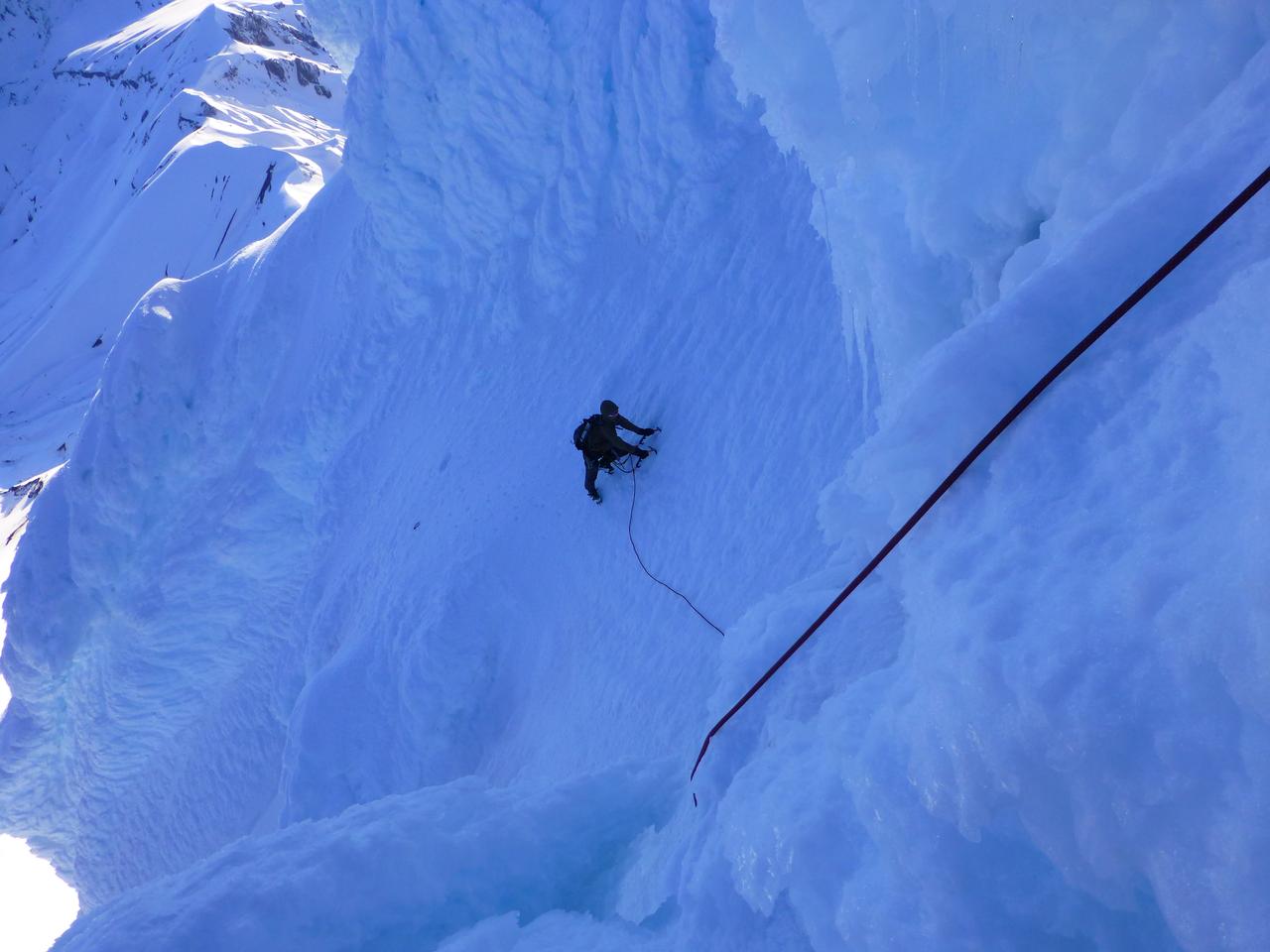
Escalamos casi todo el tiempo en solo integral, con un solo largo de cuerda de unos cinco metros de hielo casi vertical (¿70 grados quizás?), que Martín primereó sin problemas. Habíamos visto un video de la parte más dura de la escalada, pero este largo parecía más fácil, así que creíamos que la parte dura estaba más arriba. Finalmente llegamos a la cumbre y el crux nunca apareció, resulta que habíamos pasado un poco a la derecha de la pared que se ve en el video, quizás para la próxima vez...
Llegamos a la cumbre a eso de las 10 am, sacamos algunas fotos, abrazos, y empezamos los rapeles. El viento seguía soplando y se asomaban algunas nubes que venían desde el este. Antes de empezar a bajar hicimos algunas cuentas de tiempo: Hay que rapelar, caminar/esquiar hasta el campamento, desarmar todo, bajar por el bosque, y manejar hasta la aduana. Ah, tenemos que llegar a la frontera antes de las 7 pm... Un cronograma apretado, pero quizás llegamos a tiempo...
Después de unos seis rapeles y un poco de desescalada, estábamos en el fin de las dificultades. Ahí guardamos el equipo de escalada y seguimos viaje hacia el campamento, ¡hora de esquiar!. La nieve primavera estaba muy buena, pero me estaba empezando a sentir cansado, así que tuve que parar un par de veces. Esquiar con la mochila pesada, después de desarmar el campamento, se puso más interesante, pero lo peor de todo fueron unos 15 m de subida, donde no tenía ganas de sacarme los esquíes. Sobre el final de la esquiada, la nieve ya estaba muy derretida y con poco espesor, así que mejor empezar a caminar. Las últimas horas de caminata hasta el auto parecían interminables (y cansadoras), pero finalmente llegamos, más o menos a tiempo. Guardamos todo en el auto de Martín y comenzamos el viaje de vuelta a Bariloche, esperando llegar a la aduana antes de las 7 pm, donde finalmente llegamos a horario, incluso con unos minutos de sobra.
En el viaje de vuelta, vimos cómo la cumbre del Puntiagudo se empezaba a cubrir de nubes, las que venían del este cuando estábamos en la cumbre. Después de cruzar la frontera incluso cayeron algunas gotas. Creo que estuvimos bastante ben con los tiempos (no había margen para atrasarse).
Volviendo a la idea de "esquiar los volcanes" (desde la cumbre), esta vez tuve que revisar la definición de "esquiar" (esta esquiada claramente no cuenta como "esquiar desde la cumbre"). ¿Rapelar con los esquíes puestos es esquiar? ¿Y esquiar asegurado? No estoy seguro... De cualquier forma, como esta era mi primera vez en la montaña, dejé los esquíes a unos 2000 m.s.n.m., donde empezaba la escalada. Después de haber estado ahí arriba, creo que esquiar lo que escalamos está afuera de mis habilidades actuales (y probablemetne futuras), pero Martín me contó que alguien había esquiado una parte del filo ENE o ESE, quizás con alguna cuerda en el medio, no estoy seguro; quien te dice, quizás la próxima podemos ir por ese lado a ver qué se ve.
Dejando de lado los aspectos "éticos", este viaje fue muy especial para mi. No tanto un viaje de esquí, más escalada que otra cosa, pero lo especial tiene que ver con cómo salió todo: Los tres trabajamos muy bien como un equipo, cada uno haciendo su parte, todo en tiempo, sin retrasos o discusiones innecesarias, era como que todo iba fluyendo sin mucho esfuerzo, esa clase de energía que uno siente de vez en cuando. ¡Gracias al Pájaro y Martin por estar ahí!
Algunas ideas para el futuro
Bueno, hay muchos volcanes por acá cerca, y se ven muy buenos para esquiarlos. Veremos qué nos depara el próximo invierno...
Lanín
Este no tendría que estar acá, ya que lo esquié el invierno pasado. Pero después vi este vieo donde esquían la cara noreste (a partir del minuto 10:00), y se ve muy buena la bajada. También leí que los muchachos de wildsnow.com habían esquiado esa línea, así que me parece que vamos a tener que subir a ver cómo se ve...
Tronador
Este todavía está en la lista. Estuve dos veces en la cumbre, una vez por la vía Meiling-Vallmitjana (acá lo cuenta el Pájaro). Esta vía es la que esquió Sebastián de la Cruz.
En esta ruta, la última pendiente de nieve tiene unos metros de alrededor de 45 grados, el día que pasamos la nieve estaba ablandada por el sol (es la cara norte), así que parecía en buenas condiciones para esquiarla. Sin embargo, un poco más abajo, saliendo del glaciar Blanco, había una cara sur de unos 30 grados con unas partes de nieve dura, mejor no caerse ahí... También hay algunas grietas que cruzar, y algunos metros que subir, pero si las condiciones están buenas no tendría que ser mucho problema. Algunas fotos de la ruta (más fotos acá):
Ah, y casi me olvido, en realidad hay dos cumbres, no estoy seguro cuál es la más alta, pero una tiene forma de hongo cubierto con formaciones de hielo esculpidas por el viento (alas de ángel), interesante esquiar desde ahí arriba...
Villarrica
Estuve un par de veces en este volcán, pero nunca en invierno, ¿quizás el próximo?. Hay un centro de esquí ahí, así que se puede llegar con el auto hasta unos 1400 m.s.n.m., y la cumbre está a unos 2800 m.s.n.m. Las pendientes son más bien suaves, creo que menos de 30 grados, y si hay buena nieve, esos 1400 m de bajada tienen que estar buenos, eh...
Este volcán está activo, por lo general se ve una fumarola saliendo desde la cumbre, y ahí arriba se siente el olor a azufre, bastante fuerte, según de donde venga el viento. A principios de marzo de 2015 entró en erupción, estableciendo la alerta roja unos 10km a la redonda.
Puyehue
Este volcán está cerca de la frontera entre Argentina y Chile. Entró en erupción en junio de 2011, cubriendo de cenizas y arena volcánica el área de Villa La Angostura, Bariloche y práctiamente todo para el este. En la foto satelital se ve bastante claro la pluma de ceniza y el área donde cayó, una especie de cono hacia el este:
 |
| Camino a la cumbre, aunque no parezca, la de la izquierda es más alta (por poco) (foto por el Pájaro) In the road to the summit, it doesn't look like, but the one at the left is higher (by a little bit) (photo by Pájaro) |
 |
| Martín en la cumbre, Lucas y Diego caminando los últimos metros, sobre nieve dura Martín at the summit, Lucas and Diego walking up the final meters, covered in hard snow |
 |
| En la cumbre, con Guido y el Pájaro. En el horizonte, Tronador, Puntiagudo y Osorno (de izquierda a derecha) (Foto por Guido) In the summit, with Guido and Pájaro. In the horizon, Tronador, Puntiagudo and Osorno (from left to right) (Photo by Guido) |
Volvimos hasta los autos y seguimos viaje hacia el Osorno, esta vez no pensaba esquiarlo desde la cumbre. Nunca había estado en el Osorno, pero Martín me contó que era una pendiente de nieve de unos 30 grados, que se pone cada vez más empinada hasta alcanzar unos 45-50 grados. La idea de escalar esa pendiente ya me resultaba un poco incómoda en ese momento, así que ni pensar en esquiarla... Pero eso es parte de la historia de otro volcán...
Osorno
Como venía diciendo, fui por primera vez al volcán Osorno en 2012. Aquella vez subimos con las pieles unas dos horas, hasta que tuvimos que cambiar por crampones porque la nieve estaba muy dura. Dejamos los esquíes en el cambio de pendiente (a unos 2400 m.s.n.m.) y escalamos la cara oeste más o menos derecho hasta la cumbre (a unos 2650 m.s.n.m.). Después de algunas fotos y de contemplar la vista, desescalamos algunos metros hasta los esquíes y bajamos esquiando hasta el auto (o casi, en realidad, tuvimos que caminar unos 200 m). La nieve no era perfecta, pero la esquiada estuvo buena. Sin embargo, la idea era esquiarlo desde la cumbre...
 |
| Subiendo la cara oeste del Osorno, sobre nieve dura Walking up Osorno west face, over the hard snow |
 |
| Los últimos pasos hacia la cumbre, después de una escalada interesante (foto por Martín) The last steps to the top, after an interesting climb (photo by Martín) |
 |
| En la cumbre, con Martín y Lucas In the summit, with Martín and Lucas |
 |
| Algunos volcanes desde la cumbre del Osorno, de derecha a izquierda: Tronador, Puntiagudo, Puyehue, Lanín (y el lago de Todos los Santos) Some volcanos from the top of Osorno, from right to left: Tronador, Puntiagudo, Casablanca, Puyehue, Lanín (and the Todos los Santos lake) |
 |
| Desescalando la cara oeste, no voy a esquiar por esta cara... (foto por Martín) Downclimbing the west face, no skiing for me in this face... (photo by Martín) |
 |
| Y ahora sí a disfrutar de la bajada Time to enjoy the run |
Así que volví al Osorno en septiembre de 2015, con un par de amigos, una especie de "repetición" del viaje anterior, ya que también esquiamos en Casablanca. Esta vez la nieve no estaba tan dura, pero la cara oeste tenía la misma inclinación y las mismas formaciones de "alas de ángel" (esta es la cara a barlovento), lo que complicaba esquiarla. Tenía la esperanza de encontrar una pasada por la cara norte o la este, para bajar de la cumbre, y después travesear hacia la cara oeste para continuar la bajada. La cara norte resultó ser menos empinada, pero también tenía alas de ángel, así que no encontré una pasada por ahí. En cambio, la cara este parecía tener buena nieve, así que decidí bajar algunos metros por ahí hasta que pudiera empalmar la cara norte (abajo de la línea de alas de ángel) y luego continuar hacia la cara oeste.
 |
| El equipo amaneciendo en el Osorno (foto por Caro) The team sunrising at Osorno (photo by Caro) |
 |
| Track del GPS de la subida (derecho por la cara oeste) y bajada (hacia la cara este, luego para el norte, y al final traveseando de vuelta a la cara oeste) GPS track of the ascent (directly up the west face) and descent (to the east face, then north, then traversing to the west again) |
La nieve en la cara este era buena, incluso disfruté de un par de vueltas, después era el momento de empezar la travesía a la izquierda. Al principio iba todo bien, pero después la nieve se puso cada vez más dura, tuve que concentrarme bastante para no patinarme, frenase no iba a ser fácil. Parecía que si me patinaba no iba a parar hasta la linea de los árboles, unos 1400 m más abajo... Por momentos la nieve estaba más blanda y me podía relajar un poco.
Después de un rato, finalmente volví a la cara oeste, donde me encontré con mis compañeros, en el cambio de pendiente abajo de la cumbre. Ellos bajaron unos 400 m hasta el lugar donde habían dejado los esquíes, mientras que yo di un par de vueltas más en nieve dura y después (finalmente) la nieve se ablandó, así que me pude relajar un poco y disfrutar de la esquiada. Mientras más bajábamos, mejor la nieve, esa parte de la bajada estuvo muy buena.
 |
| Buscando los esquíes y comiendo algo, con Matías, Guido, Caro y Fátima Retrieving the skis and eating something, with Matías, Guido, Caro y Fátima |
Mirando un poco para atrás, esta fue la bajada en esquíes más dura que haya hecho, la travesía desde la cara este a la oeste estaba claramente en la categoría de "no vale caerse". Para la próxima, quizás un par de "whippets" no estarían mal. Según Google Earth, la pendiente máxima es de unos 33 grados, aunque me pareció un poco más empinado.
 |
| Black Diamond Whippet, un bastón apto para autodetención Black Diamond Whippet, a self-arrest ready ski pole |
Puntiagudo
Este volcán se ve realmente interesante desde distintos puntos cerca de Bariloche, se ves desde el centro de esquí de Catedral, desde la mayoría de las cumbres de la zona, desde el volcán Osorno, etc. Tiene forma de pirámide hasta los metros finales, donde se pone más empinado, incluso parece "imposible" de subir.
 |
| Cara SO del Puntiagudo, desde el Osorno. Una ruta sube por el filo NO, a la izquierda en la foto (foto por Lucas) Puntiagudo's SW face, from Osorno. One route climbs the NW ridge, the one at the left in the picture (photo by Lucas) |
 |
| Cara SE del Puntiagudo, desde la cumbre del Tronador (foto por el Pájaro) Puntiagudo's SE face, from Tronador's summit (photo by Pájaro) |
Queríamos ir con unos amigos, pero parecía que nunca coincidían las condiciones del clima con nuestras agendas personales (la idea es ir ahí cuando está cubierto de nieve e hielo, preferentemente con un clima frío).
Finalmente, hace algunos meses, todo se alineó y partimos para allá a mitad de Septiembre, con Martín y el Pájaro. Según el pronóstico, viernes y sábado eran los mejores días, pero teníamos que trabajar, así que le apuntamos a la cumbre para el domingo. Hasta el sábado las temperaturas eran buenas (la isoterma de cero grados abajo de 1200 m.s.n.m.), el domingo la temperatura iba a subir un poco, según el pronóstico, y después de eso parecía que ya llegaba la primavera, así que este era probablemente EL fin de semana de la temporada. Además, en una semana, yo me iba de viaje por trabajo por un mes, así que había pocas chances de que el Puntiagudo estuviera en condiciones para fin de Octubre.
 |
| Pronóstico del clima para Bariloche, a mitad de septiembre (el del Puntiagudo era similar, pero no lo guardé). Del 17 al 19 estaba buena la temperatura, el 19 más despejado y con menos viento. Nosotros fuimos a la cumbre el 20. Weather forecast for Bariloche, mid of September (Puntiagudo's was similar, but I didn't save it). From 17th to 19th the temperature was good, the 19th less cloudy and windy. We went to the summit on the 20th. |
El viernes, viajamos hasta el comienzo de la picada (las cabañas de Robin), dormimos ahí, y el sábado empezamos la caminata de aproximación. Hubo alguna discusión entre si llevar esquíes o no: Martín creía que no hacían falta, yo quería esquiar, así que prefería llevarlos, y el Pájaro estaba indeciso. Finalmente, yo fui con esquíes y Martín y el Pájaro fueron caminando (Martín llevó un par de raquetas de nieve, que finalmente no hicieron falta). Al final, la diferencia de tiempo de marcha entre llevar o no esquíes fue despreciable, tanto en la subida como en la bajada, principalmente porque la nieve no estaba muy honda y algunos escaladores había abierto huella los días anteriores (subieron a la cumbre el viernes y el sábado).
El camino transcurre por la selva valdiviana durante unos 7 km, donde se llega a la base del volcán. Desde ahí seguimos subiendo un par de horas hasta que llegamos a un lugar para acampar, a unos 1500 m.s.n.m.. El Puntiagudo no es de los volcanes más altos (unos 2500 m.s.n.m.), pero la senda arranca a unos 200 m.s.n.m., así que el desnivel no es despreciable, con unos 2300 m en total. En el lugar de acampe nos encontramos con unos chilenos, dos de ellos habían subido a la cumbre el viernes, y ya estaban bajando, así que aprovechamos para usar el lugar para la carpa que ellos habían armado.
 |
| El Pájaro, llenando el registro de trekking, en las cabañas de Robin Pájaro, filling the trekking log, in Robin's lodge |
 |
| Llegando a lo de don Paulino, no está mal la vista, ¿no? Arriving at Paulino's place, the view ain't bad, isn't it? |
 |
| Saliendo del bosque, algo de nieve hay... Getting out of the forest, there is some snow... |
 |
| El Pájaro y Martín rumbo al lugar de acampe Pájaro and Martín in the way up to the camp site |
 |
| Hogar dulce hogar, por una noche (foto por Martín) Home sweet home, for one night (phot by Martín) |
 |
| Cinco escaladores cerca de la cubre, el sábado a la tarde (foto por el Pájaro) Five climbers near the summit, Saturday's afternoon (phot by Pájaro) |
 |
| Los muchachos a tono con el atardecer The boys in line with with the sunset |
 |
| Se viene la noche, lagos Rupanco y Puyehue de fondo The night is coming, Rupanco and Puyehue lakes at the bottom |
Al otro día sonó el despertador, a eso de las 4:00 a, un par de mates de desayuno con un poco de comida, y ya es hora de empezar a caminar / foquear. Al amanecer llegamos a una parte plana cerca del comienzo de la escalada (a unos 2000 m.s.n.m.), ahí dejé los esquíes y nos pusimos los crampones. A esta altura, el viento empezaba a soplar, un poco adelantado al pronóstico. El viento venía del este, algo no muy común en la zona, donde el viento sopla del oeste o noroeste, por lo general.
El sol empezaba a salir cuando comenzamos a escalar, siguiendo las huellas de los escaladores de los días anteriores. El viento soplaba, pero estábamos más o menos reparados por la montaña ya que subíamos por el filo nornoroeste.
 |
| Transiciones, de esquíes a crampones y bastones a piquetas Transitions, from skis to crampons and poles to ice axes |
 |
| Martín empezando a escalar Martín starting the climb |
 |
| Fuera de foco, la foto, vos mejor mantenete enfocado... Out of focus, the picture, you better stay focused.. |
Escalamos casi todo el tiempo en solo integral, con un solo largo de cuerda de unos cinco metros de hielo casi vertical (¿70 grados quizás?), que Martín primereó sin problemas. Habíamos visto un video de la parte más dura de la escalada, pero este largo parecía más fácil, así que creíamos que la parte dura estaba más arriba. Finalmente llegamos a la cumbre y el crux nunca apareció, resulta que habíamos pasado un poco a la derecha de la pared que se ve en el video, quizás para la próxima vez...
 |
| "Parece que ahí se pone duro", Martín llegando al crux, con la sombra del puntiagudo al amanecer "It seems it gets harder there", Martín getting to the crux, with Puntiagudo's shadow at dawn |
 |
| Así que mejor nos encordamos... (foto por el Pájaro) So we better rope up... (photo by Pájaro) |
 |
| Empezando el largo más duro (foto por el Pájaro) Following the hardest pitch (photo by Pájaro) |
 |
| El Pájaro escalando, los lagos de fondo, con las nubes bajas de la mañana Pájaro climbing, the lakes at the background, with some morning low clouds |
 |
| Martín y el Pájaro camino a la cumbre Martín and Pájaro in the way to the summit |
 |
| "¿Va bien ahí che?" (foto por Martín) "¿How's the climb up there?" (photo by Martín) |
 |
| Ya casi estamos, parece que falta poco... Almost there, it seems we are close |
 |
| Escalando la última rampa a la cubre, mejor no mirar para abajo... (foto por Martín) Climbing the last ramp to the summit, better not to look down... (photo by Martín) |
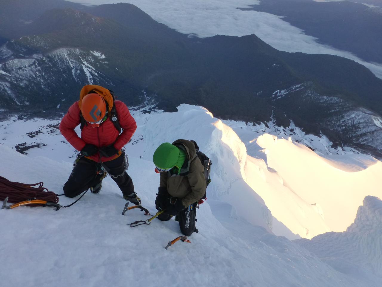
Llegamos a la cumbre a eso de las 10 am, sacamos algunas fotos, abrazos, y empezamos los rapeles. El viento seguía soplando y se asomaban algunas nubes que venían desde el este. Antes de empezar a bajar hicimos algunas cuentas de tiempo: Hay que rapelar, caminar/esquiar hasta el campamento, desarmar todo, bajar por el bosque, y manejar hasta la aduana. Ah, tenemos que llegar a la frontera antes de las 7 pm... Un cronograma apretado, pero quizás llegamos a tiempo...
 |
| "¿Cómo está esa cumbre Martín?" "How's that summit Martín?" |
 |
| Foto de cumbre Summit picture |
 |
| El Pájaro empezando los rapeles Pájaro starting the rappels |
 |
| ¿Aguanta ese hongo? parece que sí eh... That bollard holds? It looks like eh... |
Después de unos seis rapeles y un poco de desescalada, estábamos en el fin de las dificultades. Ahí guardamos el equipo de escalada y seguimos viaje hacia el campamento, ¡hora de esquiar!. La nieve primavera estaba muy buena, pero me estaba empezando a sentir cansado, así que tuve que parar un par de veces. Esquiar con la mochila pesada, después de desarmar el campamento, se puso más interesante, pero lo peor de todo fueron unos 15 m de subida, donde no tenía ganas de sacarme los esquíes. Sobre el final de la esquiada, la nieve ya estaba muy derretida y con poco espesor, así que mejor empezar a caminar. Las últimas horas de caminata hasta el auto parecían interminables (y cansadoras), pero finalmente llegamos, más o menos a tiempo. Guardamos todo en el auto de Martín y comenzamos el viaje de vuelta a Bariloche, esperando llegar a la aduana antes de las 7 pm, donde finalmente llegamos a horario, incluso con unos minutos de sobra.
 |
| Fin de las dificultades End of the difficulties |
 |
| El Tronador entre las nubes, se viene el pesto (del este)... Tronador between clouds, bad weather is coming (from the east)... |
 |
| La línea seguida (foto por el Pájaro, topo por Martín) The line we followed (photo by Pájaro, topo by Martín) |
En el viaje de vuelta, vimos cómo la cumbre del Puntiagudo se empezaba a cubrir de nubes, las que venían del este cuando estábamos en la cumbre. Después de cruzar la frontera incluso cayeron algunas gotas. Creo que estuvimos bastante ben con los tiempos (no había margen para atrasarse).
Volviendo a la idea de "esquiar los volcanes" (desde la cumbre), esta vez tuve que revisar la definición de "esquiar" (esta esquiada claramente no cuenta como "esquiar desde la cumbre"). ¿Rapelar con los esquíes puestos es esquiar? ¿Y esquiar asegurado? No estoy seguro... De cualquier forma, como esta era mi primera vez en la montaña, dejé los esquíes a unos 2000 m.s.n.m., donde empezaba la escalada. Después de haber estado ahí arriba, creo que esquiar lo que escalamos está afuera de mis habilidades actuales (y probablemetne futuras), pero Martín me contó que alguien había esquiado una parte del filo ENE o ESE, quizás con alguna cuerda en el medio, no estoy seguro; quien te dice, quizás la próxima podemos ir por ese lado a ver qué se ve.
Dejando de lado los aspectos "éticos", este viaje fue muy especial para mi. No tanto un viaje de esquí, más escalada que otra cosa, pero lo especial tiene que ver con cómo salió todo: Los tres trabajamos muy bien como un equipo, cada uno haciendo su parte, todo en tiempo, sin retrasos o discusiones innecesarias, era como que todo iba fluyendo sin mucho esfuerzo, esa clase de energía que uno siente de vez en cuando. ¡Gracias al Pájaro y Martin por estar ahí!
 |
| El equipo, de vuelta en el auto The team, back at the car |
Algunas ideas para el futuro
Bueno, hay muchos volcanes por acá cerca, y se ven muy buenos para esquiarlos. Veremos qué nos depara el próximo invierno...
Lanín
Este no tendría que estar acá, ya que lo esquié el invierno pasado. Pero después vi este vieo donde esquían la cara noreste (a partir del minuto 10:00), y se ve muy buena la bajada. También leí que los muchachos de wildsnow.com habían esquiado esa línea, así que me parece que vamos a tener que subir a ver cómo se ve...
 |
| Volcán Lanín, la cara NE es la que está en la sombra Lanín volcano, the NE face is the one in the shadow |
 |
| Los chicos de wildsnow.com esquiando la cara NE (más información acá) The wildsnow.com boys skiing the NE face (more info here) |
 |
| Captura del video "A skier's journey - Argentina", no está tan mal la pendiente, eh... Video capture of "A skier's journey - Argentina", the slope ain't so bad, eh... |
Tronador
Este todavía está en la lista. Estuve dos veces en la cumbre, una vez por la vía Meiling-Vallmitjana (acá lo cuenta el Pájaro). Esta vía es la que esquió Sebastián de la Cruz.
 |
| "Sebastián de la Cruz en la cima del Internacional del Tronador, antes de efectuar su descenso por las caras Norte, Oeste y Sur" (Club Andino Bariloche, Memoria 2005-2011, 80 aniversario) "Sebastián de la Cruz on Tronador's International summit, before starting his descent on the North, West and South faces" (Club Andino Bariloche, Memoria 2005-2011, 80 aniversario) |
 |
| "Vista aérea del glaciar Blanco y la pared Sur del Internacional. La ruta señalada es la que bajaron esquiando Sebastián de la Cruz y Mariano Lopez" (Club Andino Bariloche, Memoria 2005-2011, 80 aniversario) "Aerial view of Blanco glaciar and South face of the International peak. The marked route is the one skied by Sebastián de la Cruz and Mariano Lopez" (Club Andino Bariloche, Memoria 2005-2011, 80 aniversario) |
En esta ruta, la última pendiente de nieve tiene unos metros de alrededor de 45 grados, el día que pasamos la nieve estaba ablandada por el sol (es la cara norte), así que parecía en buenas condiciones para esquiarla. Sin embargo, un poco más abajo, saliendo del glaciar Blanco, había una cara sur de unos 30 grados con unas partes de nieve dura, mejor no caerse ahí... También hay algunas grietas que cruzar, y algunos metros que subir, pero si las condiciones están buenas no tendría que ser mucho problema. Algunas fotos de la ruta (más fotos acá):
 |
| Vista del Tronador desde Pampa Linda, la ruta Meiling-Vallmitjana cruza el glaciar Manso (el más grande que se ve en la foto) de derecha a izquierda, por arriba, para llegar al filo de la izquierda y subirse al glaciar Blanco (Foto por el Pájaro) Tronador from Pampa Linda, the Meiling-Vallmitjana route crosses the Manso glacier (the bigger one in the picture) from right to left, in the upper part, to join the Blanco glacier in the left ridge (Photo by Pájaro) |
 |
| Subiéndonos al glaciar Blanco, atrás del filo está el glaciar Manso Getting up the Blanco glaciar, Manso glacier is beneath the ridge |
 |
| Pasando por al lado de la cara sur del pico principal del Tronador, hacia el filo del fondo. Passing by the south face of Tronador's main summit, aiming to the ridge at the bottom. |
 |
| En el filo del glaciar Blanco, llegando al col Reichert In the ridge of Blanco glacier, towars Reichert col |
 |
| Últimos pasos a la cumbre, hay que travesear por abajo de las piedras de la izquierda y luego subir por la pala de nieve final (cara norte) (foto por el Pájaro) Last steps to the summit, you have to traverse to the left, below the rocks, to gain the final snow slope to the summit (north face) (photo by Pájaro) |
 |
| Manque en la última pendiente de nieve, no vale caerse... Manque in the last snow slope, non-falling zone... |
 |
| Destrepando el filo del Blanco, no te patines en esa nieve dura... (Foto por el Pájaro) Downclimbing the Blanco ridge, don't slip in that hard snow... (Photo by Pájaro) |
Ah, y casi me olvido, en realidad hay dos cumbres, no estoy seguro cuál es la más alta, pero una tiene forma de hongo cubierto con formaciones de hielo esculpidas por el viento (alas de ángel), interesante esquiar desde ahí arriba...
 |
| Martín y el Pájaro en la cumbre, Matías llegando a la otra cumbre, ¿cuál es más alta? No estoy seguro... Martín and Pájaro in the summit, Matías arriving to the other summit, which one is higher? I don't know... |
Villarrica
Estuve un par de veces en este volcán, pero nunca en invierno, ¿quizás el próximo?. Hay un centro de esquí ahí, así que se puede llegar con el auto hasta unos 1400 m.s.n.m., y la cumbre está a unos 2800 m.s.n.m. Las pendientes son más bien suaves, creo que menos de 30 grados, y si hay buena nieve, esos 1400 m de bajada tienen que estar buenos, eh...
Este volcán está activo, por lo general se ve una fumarola saliendo desde la cumbre, y ahí arriba se siente el olor a azufre, bastante fuerte, según de donde venga el viento. A principios de marzo de 2015 entró en erupción, estableciendo la alerta roja unos 10km a la redonda.
 |
| Volcán Villarrica al atardecer, desde la ruta cerca de Pucón Villarrica volcano at dusk, from the road near to Pucón |
 |
| Villarrica y su fumarola, desde el centro de Pucón (si, está cerca...) Villarrica and its fumarole, from Pucón (yes, it is close...) |
 |
| Panorámica de la cumbre del Villarrica, con su fumarola. En verano puede estar medio concurrido... Villarrica's summit panorama, whit its fumarole. It can get a little bit crowded in summer... |
Puyehue
Este volcán está cerca de la frontera entre Argentina y Chile. Entró en erupción en junio de 2011, cubriendo de cenizas y arena volcánica el área de Villa La Angostura, Bariloche y práctiamente todo para el este. En la foto satelital se ve bastante claro la pluma de ceniza y el área donde cayó, una especie de cono hacia el este:
 |
| Erupción del Puyehue / Cordón Caulle, foto del 13 de junio de 2011, del satélite Terra, más info acá. Puyehue / Cordón Caulle eruption, photo from June 13th 2011, from Terra satellite, more info here. |
 |
| Detalle de la pluma de ceniza el día de la erupción, unos 6 km al norte del cráter principal (más info) Ash plume detail, the day of the eruption, about 6 km north of the main crater (more info) |
He visto fotos y videos de gente esquiando, pero nunca fui. Se lo ve bastante bueno desde las cumbres cercanas:
 |
| Volcán Puyehe, desde el cerro Mirador, un poco más al este, junio 2015. Puyehue volcano, from nearby hill Mirador, a little bit to the east, June 2015. |
 |
| Puyehue y Lanín desde la cumbre del Osorno, esa es la cara sur, con unos 900 m de desnivel, buena bajada eh... (foto por Lucas) Puyehue and Lanín from Osorno's summit, that's the south face, about 900 m of descent, that should be a good one... (photo by Lucas) |
 |
| Puyehue entre las nubes, desde el cerro Campana, ¿3500 m de altura? Puyehue beneath the clouds, from Campana hill, 3500 m high? |
Tiene una forma un tanto particular para un volcán, sin la típica forma de pirámide. El cráter principal tiene 2000 metros de diámetro, por suerte no estuve ahí cuando explotó... (la erupción de 2011 no fue en el cráter principal, sino en una falla cercana, hacia el norte, como se ve en la foto arriba).
Mocho / Choshuenco
Este volcán está cerca de San Martín de los Ándes, cruzando a Chile por el paso Hua Hum. Hay un cruce de un lago por un ferri y, en la otra orilla, el volcán se ve desde la costa. De hecho, son dos volcanes: Mocho (el del cráter más grande) y Choshuenco (hacia el noroeste), separados por una caminata de unos 3 km. Estos volcanes los vi por primera vez durante un viaje en bicicleta en 2011, de hecho solo vi la nieve, porque las cumbres estaban nubladas.
Unos amigos estuvieron ahí hace nos años, pero nunca busqué demasiada información, no tengo idea de dónde comienza la senda. No hay centro de esquí, así que la aproximación puede ser un poco larga.
 |
| Mocho / Choshuenco entre las nubes, desde el fery cerca de Puerto Fuy. Mocho / Choshuenco between the clouds, from the ferry near Puerto Fuy. |
 |
| Mocho / Choshuenco desde el volcán Osorno, allá lejos en el horizonte (foto por Lucas) Mocho / Choshuenco from Osorno volcano, far away in the horizon (photo by Lucas) |
 |
| Mocho / Choshuenco desde la cumbre del Lanín. Mocho / Choshuenco from Lanín summit. |
Llaima y Lonquimay
Estos volcanes los he visto en los mapas, y desde el Lanín, allá lejos hacia el noroeste. Mi amigo el Pájaro estuvo ahí. La única parte mala es que hay que manejar medio día, al menos, para llegar, y otro tanto para volver (uno 1000 km ida y vuelta). Quizás un día de estos, veremos...
 |
| Volcán Llaima, desde el centro de esquí del Villarrica. Llaima volcano, from Villarrica's ski center. |
 |
| Cerro Las Peinetas, Llaima atrás a la izquierda, y Lonquimay más atrás a la derecha, desde el volcán Lanín. Las Peinetas hill, Llaima in the background, to the left, and Lonquimay at the bottom, to the right, from Lanín volcano. |
 |
| De izquierda a derecha: Llaima, Tolguaca, Lonquimay y Sierra Nevada, desde la cumbre del cerro San Sebastián, en el parque nacional Huerquehue, Chile From left to right: Llaima, Tolguaca, Lonquimay and Sierra Nevada, from San Sebastián's hill summit, Huerquehue national park, Chile |
Lanín
Lanín volcano is a special mountain for me. In a way, it was the first big mountain I attempted to climb. I went there whit my friend Cristian and a guide in the summer of 2009.
The idea was to walk to the top, no skiing this time. I had little or none experience on snow and ice climbing, and my friend was in a similar situation. We arrived to the camp site in time, but the next day the wind picked up so we had to go down. That night I couldn't sleep, may be due to the winds, the anxiety, or both.
Some years later I went back again in early November and stood at the top with Martín, in a day push to the summit. It was windy again, and cold, but we enjoy the effort and the summit. there wasn't too much time to contemplate the landscape: Two pictures and "let's get out of here".
This past August I headed to Lanín again for a winter attempt, this time with Matías, hopping to find some good snow to ski. We planed for a two day ascent, sleeping in the RIM Hut. It had snowed the previous night, so we put on our skis literally besides the car. We skinned up without too much hurry, Matias's skins where glopping up, and up in the ridge the wind picked up a little bit, so we arrived at the hut near sunset.
The next day we started about 4 am towards the summit, skinning for about 2 hr until the hard snow and the increasing slope asked for some crampons. We stood at the summit about midday, I was carrying my skis, since I was hopping to ski down from the top, while Matias left them at "el plató", at about 3000 m.a.s.l.
At the summit the wind was blowing, again, but at least this time we could shelter beside a snow ridge near the top. The snow near the summit had some big rime ice formation, so the skiing was rather "surviving mode" during the first turns. After some meters, I got to the steepest part of the descent, clearly where you don't want to fall. I did one more turn than needed and ended in a tight passage, where I had two options: To jump to one side (about a meter or so), or go straight down for some meters and then slow down, without too much space. I opted for the speed instead of the jump.
Everything was going according to the plan, but when I tried to stop, the force was too much and one binding jumped out, leaving me with one ski sliding head first in the snow slope. There I remembered about the self arrest maneuver, how was that? Ah, first head up, OK, now step into your hands and feet, fortunately it worked, thanks mainly to the soft snow and the fact that I had only one ski.
After stopping, I checked that every part of myself was in place, it was; then I looked for my ski, which was some 10 m up the slope. That was a lucky fall, I think... For the next steep descent, better to tight up a little bit the vertical release of the bindings (the lateral release can be blocked, in a Dynafit like binding -NOT recommended by the manufacturer-, but the vertical release is only held by the binding springs).
Besides that fall, the rest of the descent went fine. We retrieved Matias skis and continue down to the hut. The snow was bad or awful (hard, wind blown snow), but that's better than no snow, in my view. After some time, we got back to the hut, eat something, packed everything and continue with the descent. And there the magic happened: In an east face bellow the hut, we found the best snow of the trip (and of the season, in fact), powder snow piled up by the wind (yes, not the safest conditions from an avalanche point of view). Even with a heavy pack, the ski was really good! I even thought of going up again, but may be for the next trip...
The ski run from the top of Lanín is a really long one, about 2600 m of continuous skiing, no need for transitions, really an almost perfect pyramid, highly recommended! Just remember to be careful in the steepest part, better not to fall...
Casablanca / Antillanca group
In
September 2012 I went with some friends in a ski mountaineering trip.
The idea was to climb Osorno volcano, and also to ski in Casablanca volcano, where Antillanca ski resort lies. These two volcanos are in Chile, near Bariloche (about 4 hs drive to Osorno ski resort base).
So on Saturday we traveled to Casablanca, something like a 3 hr trip from Bariloche, including the border cross to Chile. The place is really nice for skiing, a lot of hills of moderate steepness, some volcanic craters to see, one really big with a diameter of about 700 m . Casablanca's summit is behind the hills you see from the parking at the ski center.
So on Saturday we traveled to Casablanca, something like a 3 hr trip from Bariloche, including the border cross to Chile. The place is really nice for skiing, a lot of hills of moderate steepness, some volcanic craters to see, one really big with a diameter of about 700 m . Casablanca's summit is behind the hills you see from the parking at the ski center.
This
day should be an "easy day" in our plans, so we skinned up to the
summit through the less resistance path. The climb was good and
enjoyable, up to the last 100 m to the summit where we find some hard
snow, so better to concentrate in the skinning! (or to walk up).
We
took some pictures in the top, and then skied down. The sun softened
snow in the west face was in good conditions for skiing. We skied down
the same path than on the up, which was rather flat in some places, and
with no snow in others, so we had a little bit of walking.
We got back to the cars and headed towards Osorno base, which I would not ski from the top this time. I haven't been on Osorno, but Martín told me that it was a snow walk up a slope of about 30 degrees, which steepens in the final meters to about 45-50 degrees. The idea of climbing that slope was a little bit uncomfortable for me, based on my experience, never mind skiing it... But this is part of another volcano story...
We got back to the cars and headed towards Osorno base, which I would not ski from the top this time. I haven't been on Osorno, but Martín told me that it was a snow walk up a slope of about 30 degrees, which steepens in the final meters to about 45-50 degrees. The idea of climbing that slope was a little bit uncomfortable for me, based on my experience, never mind skiing it... But this is part of another volcano story...
Osorno
As I was saying before, I first went to Osorno volcano in 2012. That time, we skinned up about two hours until we had to revert to walking, because the snow was really hard. We left the skis where the slope steepens (at about 2400 m.a.s.l.) and climbed the west face more or less directly to the top (about 2650 m.a.s.l.). Then, after some pictures, we downclimbed some meters and skied all the way down to the cars (almost, there was a 200 m walk). The snow wasn't perfect, but the skiing was good. Nevertheless, the idea was to ski it from the top...
So I came back to Osorno in September 2015, with a couple of friends, kind of a "repeat" of the previous trip, since we also went to Casablanca. This time the snow wasn't so hard, but the west face had the same steepness and some rime ice formations (this is the windward slope), which make it difficult to ski it. I hopped to find a way down from the top, may be the north face or the east face, and then traverse again to the west face. The north face turned out to be less steep than the west face (good to know for the next time) but it also had rime ice, so I didn't saw a way there. In contrast, the west face seemed to have good snow, so I opt for descending some meters there, until I could join the north face (bellow the rime ice line) and then continue the traverse to the west face.
The snow on the east face was good, I even enjoy some turns, then it was time to traverse. Everything went fine at first, but then the snow turned harder and harder, I needed to really concentrate not to slip, because it would be difficult to stop. It looked like if I fall I wouldn't stop until the tree line 1400 me below... For some moments, the snow was a little bit softer and I could release some tension.
After some time I finally got back to the west face, where I joined my partners at the slope change beneath the summit. They walk down about 400 m to retrieve their skis, I made a couple of turns in hard snow and then (finally) it softened , so I could relax a little bit and start enjoying the descent. The lower we got, the better the snow, that part of the skiing was really good.
In hindsight, this was the hardest ski descent I've done, the traverse from the east to the west face was in the "non falling zone". For the next time, may be a pair of "whippets" would add to safety. According to google earth, the slope is about 33 degrees, certainly it felt like more.
Puntiagudo
This volcano looks really interesting from different points of view near Bariloche, you can see it from Catedral ski center, from most of the summits near Bariloche, from Osorno volcano and so on. It has a pyramid like shape until the final meters, where it steepens, even looking "impossible" to climb.
We wanted to go there whit a couple of friends, but the wright conditions never seemed to fit in with our personal schedules (the idea is to go there when it's covered with snow and ice, preferably in cold conditions).
Finally, some months ago, everything aligned and we went there in mid September, whit Martín and Pájaro. According to the forecast, the best summit days were Friday and Saturday, but we had to work, so we aimed for the summit on Sunday. Up to Saturday the temperatures were good (0° C isotherm under 1200 m.a.s.l.), on Sunday the temperature was expected to increase and after that it seemed that spring was arriving, so this was probably THE weekend of the season. Moreover, in a week I had to go in a work trip for a month, so practically no chance Puntiagudo would be in conditions at the end of October.
We traveled to the start of the trail on Friday afternoon (Robin's lodge), slept there, and start the approach walk on Saturday. There was some discussion to whether or not carry skis: Martín thought they weren't necessary, I wanted to ski, so I was favoring carrying them, while Pájaro was doubting what to choose. Finally, I went with the skis and Martín and Pajaro went without (Martín carried a pair of snow shoes which finally weren't necessary). In the end, the difference in time of travel, both up and down, was negligible, mainly because the snow wasn't too deep and some climbers have braked trail the days before (they went to the summit on Friday and Saturday).
The trail goes through the valdivian temperate rain forest for about 7 km, where it gets to the base of the volcano. From there we continue the ascent for a couple of hours until we got to our camping spot, at about 1500 m.a.s.l. Puntiagudo isn't the highest volcano of the zone (about 2500 m.a.s.l.), but the trail stars at about 200 m.a.s.l., so the elevation gain is no minor, about 2300 m in total. At the camp site, we met some chileans, two of them have gone to the top on Friday, and they where going down, so we used their camp site once they left.
The next day, about 4:00 am the alarm ringed, some mates whit cookies for breakfast and time to start walking/skinning. About dawn we got to a flat section near the start of the climb (at about 2000 m.a.s.l.), I left my skis there and we switch to crampons. At this time, the wind was starting to pick up, some hours before than the forecast prediction. It was coming from the east, not so common in this area, where the prevailing winds are from the west and northwest.
The sun was coming up and we started climbing, following the steps marked by other parties on Friday and Saturday. The wind was blowing, but we where more or less protected by the mountain since we were on the NNW ridge.
We free soled most of the way up, with only one pitch of about 5 m of near vertical ice (70 degrees? maybe), which Martín lead with no problem. We've seen a video of the most difficult part of the climb, but this pitch seemed easier, so we thought we may found the crux higher in the mountain. But we ended up in the summit and the crux never arrived, in happened that we had gone to the right of the wall shown on the video, may be the next time...
We got to the top at about 10 am, took some pictures, hug in, and started the rappels. The wind was blowing and some clouds were approaching from the east. Before we start the way down, we made some time calculations: Rappels, walk/ski down to camp, pack everything, walk back through the forest, and drive to the border. Ah, we have to cross the border, it closes at 7 pm... Tight schedule, but we may be on time...
After about six rappels and some downclimb, we where at the end of the difficulties. There we packed the climbing gear and continue down to the tent, time to ski! The sun softened snow was really good for skiing, I was starting to feel tired so I had to stop a couple of times. Skiing with a heavy pack, after packing the tent, was kind of challenging, but the worst part was a short climb of about 15 m, were I didn't want to take my skis off. The final meters of snow where really thin and melted spring snow, so better start walking. The last couple of hours through the forest where rather tiring and endless, but we finally made it to the car, more or less on time. We packed everything in Martín's car and started the way back to Bariloche, hopping to arrive at the border before 7pm, what we finally did, even whit some minutes of margin.
When we where driving out, the summit of Puntiagudo was staring to fill whit clouds, the ones we saw coming from the east at the top. After crossing the border, it also started to rain. I think this trip's timing was perfect (no margin for delays).
Going back to the idea of "skiing the volcanos" (from the top), this time I had to revise the definition of "skiing" (this trip clearly doesn't count as "ski from the top"). Is rappelling with your skis on skiing? and what about skiing on belay? I'm not sure... Nevertheless, as this was my first time in the mountain, I left my skis at about 2000 m.a.s.l., when the climbing started. After being up there, I think skiing what we climb is out of my abilities right now (and may be ever), but Martín told me someone had skied some part of the ENE or ESE ridge, with some rope in the middle, don't know exactly how; who knows, may be the next time we can go and have a look somewhere there.
"Ethical" aspects aside, this trip was really special for me. Not so much of a skiing trip, mainly climbing, but the special part has to do with how everything went out: The three of us worked really well as a team, everyone doing his part, all in time, no delays or conflicts or discussions, it was like everything was flowing really smooth, that kind of good energy that you get once in a while. Thanks to Martín and Pájaro for being part of it!
Some ideas for the future
Well, there are a lot of volcanos nearby, they look really god for skiing, lets see what the next winter gives us...
Well, there are a lot of volcanos nearby, they look really god for skiing, lets see what the next winter gives us...
Lanín
This one should not be here, since I've ski it the past winter. But then I saw this video where they ski the northeast face (starting at minute 10:00), and it looks good. I've also seen the wildsnow.com guys skiing that line, so I think we should go up there and take a look...
Tronador
This one is still on the list. I've been two times in the summit, once through the Meiling-Vallmitjana route (Pajaro's report here). This route is the one that Sebastian de la Cruz skied.
The final slope has some meters of around 45 degrees, the day I was there the snow was softened by the sun (it's a north face), so it was in good conditions for skiing. Nevertheless, in the way out the glaciar Blanco (white glacier) there was a south slope of about 30 deg with some hard snow, you want to be sure not to slip there... There are also some crevasses to negotiate, and a some meters of climbing, but in good conditions it should be no problem. Some pictures of the route, above, and some more here.
And I almost forgot, there are two summits, don't know exactly which one is higher, but one is like a big mushroom covered in rime ice, interesting to ski from there...
Villarrica
I've been there tow times, but never in winter, may be the next one?. There is a ski center there, so you can drive to about 1400 m.a.s.l. and the summit is about 2800 m.a.s.l. The slope is rather gentle, I think it's less than 30 deg all the way to the top, and if there is good snow coverage that 1400 m descent should be a good one!.
This is an active volcano, you can see a fumarole coming out of its summit, and up there you can smell the sulfur odor, pretty strong sometimes, depending on the wind direction. The volcano erupted at beginning of march 2015, establishing a 10 km exclusion zone.
Puyehue
This volcano is near the border cross between Argentina and Chile. It erupted in June 2011, covering with ashes and volcanic sand the area of Villa La Angostura, Bariloche and a big are to the east. This is clearly visible in the satellite photos, showing the plume and the ashes in a kind of cone to the east.
I've seen some pictures and videos of people skiing it, but I've never been there. It looks good from nearby hills (see pictures above).
It has a strange form for a volcano, without the typical pyramid shape. The main crater is about 2000 m in diameter, fortunately I wasn't there when it erupted... (the eruption of 2011 wasn't at the main crater but in a nearby fault to the north, as can be seen in the photograph).
Mocho / Choshuenco
This
volcano is near San Martín de los Andes, crossing to Chile by the Hua Hum pass. There is a
lake cross up in a ferry and, in the other side, the volcano is near the
shore. In fact, they are two volcanos: Mocho (the big crater) and Choshuenco (to the northwest), separated by about a 3 km walk. I first saw these volcanos during a biking trip back in 2011, in fact I only saw the snow, because it was a little bit cloudy.
A couple of friends climbed it, but I never looked up for information, I have no idea were the trail starts. There is no ski center, so you may have to walk a little bit in the approach.
A couple of friends climbed it, but I never looked up for information, I have no idea were the trail starts. There is no ski center, so you may have to walk a little bit in the approach.
Llaima and Lonquimay
I've seen these volcanos in the map and some pictures, also from Lanín, far away to the northwest. My friend Pájaro have been there. The down side is that you have to drive about half a day to go, and another one to get back (about 1000 km total). May be one of these days, time will tell...
No hay comentarios.:
Publicar un comentario